 Loading...
Do you have a question about the Honda 2008 CR- V and is the answer not in the manual?
| Display Type | LCD |
|---|---|
| Voice Recognition | Yes |
| Points of Interest | Yes |
| GPS | Yes |
| Resolution | 480 x 234 pixels |
| Voice Guidance | Yes |
| Auxiliary Input | Yes |
| GPS Antenna | Internal |
| Map Updates | DVD |
| Map Coverage | North America |
| Traffic Information | XM NavTraffic (subscription required) |
Divides the manual into sections for easy understanding of system features.
Explains the navigation system's sophisticated location capabilities using GPS and sensors.
Warns about potential distractions from the navigation system while driving.
Explains the map display features and differentiates between verified and unverified streets.
Identifies and explains the function of the navigation system's physical and screen controls.
Introduces the voice control system, its buttons, and microphone.
Provides instructions on how to use voice commands effectively for system operation.
Explains how to select items using voice, touch screen, or joystick.
Explains how to input text using the on-screen keyboard and voice.
Describes the initial boot-up sequence, globe screen, and disclaimer.
Explains the meaning of icons, symbols, and colors on the map screen.
Details map features like zoom, scrolling, and displaying current location.
Guides on entering a destination by specifying street address, city, and state.
Describes finding destinations by category, name, or phone number.
Guides on storing, retrieving, and managing personal addresses.
Provides a quick way to navigate to a pre-set home address.
Describes the process of calculating a route and adding destinations to the trip.
Explains how to select different route calculation preferences like Direct or Easy Route.
Details how the system provides turn-by-turn navigation instructions before maneuvers.
Explains the option to display map and guidance information simultaneously.
Explains route recalculation when deviating from the planned path.
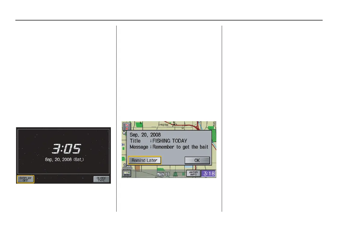
Shows how to view and save current location details like address and coordinates.
Introduces methods for altering the current route, like adding waypoints.
Details how to adjust screen brightness for optimal viewing.
Explains screen display modes (Day, Night, Auto) and settings.
Accesses personal settings like Address Book, Home Address, PIN, and Previous Destinations.
Allows setting a PIN for privacy and security of personal data.
Accesses settings for route calculation preferences and guidance options.
Compares routing differences when using unverified roads versus verified roads.
Allows users to define specific areas to be avoided during route calculation.
Explains the process of entering the anti-theft security code after power loss.
Describes the process of reacquiring GPS satellite information.
Outlines inherent limitations of the navigation system's accuracy and features.
Discusses factors that can interfere with GPS signal reception.
Guides on how to report database errors or system issues.
Explains how to purchase updated navigation system DVDs.
Provides instructions for replacing the navigation system DVD.
Outlines the geographical areas covered by the navigation system maps.
Lists US states and metropolitan areas with detailed map coverage.
Lists Canadian provinces and cities with map coverage details.
Answers questions related to navigation guidance, route calculation, and map display.
Provides solutions for various system error messages encountered during operation.
Defines terms used throughout the navigation system manual.
Lists voice commands applicable on any screen.
Lists voice commands for map and guidance screens.
Lists voice commands for finding various points of interest.
Lists voice commands for controlling the radio and audio system.