EasyManuals Logo

Garmin Colorado Series User Manual

Garmin Colorado Series
64 pages
To Next Page IconTo Next Page
To Previous Page IconTo Previous Page
Page #21 background imageLoading...
Page #21 background image
To
pan
across
the
map:
1
To
start
panning,
press
up,
down,
left,
and
right
on
the
Rock
'n
Roller
to
move
the
pointer
on
the
map.
2.
Select
Done
to
stop
panning.
To
review
a
point
on
the
map:
1.
When
the
pointer
is
on
a
location
you
want
to
review,
press
ENTER.
Detailed
information
about
the
selected
point
appears.
2.
Select
Back
when
finished.
3.
Select
Done
to
stop
panning.
ApPLICATIONS
ApPLICATIONS
Map
Page
To
access
the
Map
page
select
Shortcuts>
Map.
To
zoom
in
and
out
on
the
Map
page:
1.
Rotate
the
Rock
'n
Roller
clockwise
to
zoom
in.
2.
Rotate
the
Rock
'n
Roller
counter-clockwise
to
zoom
out.
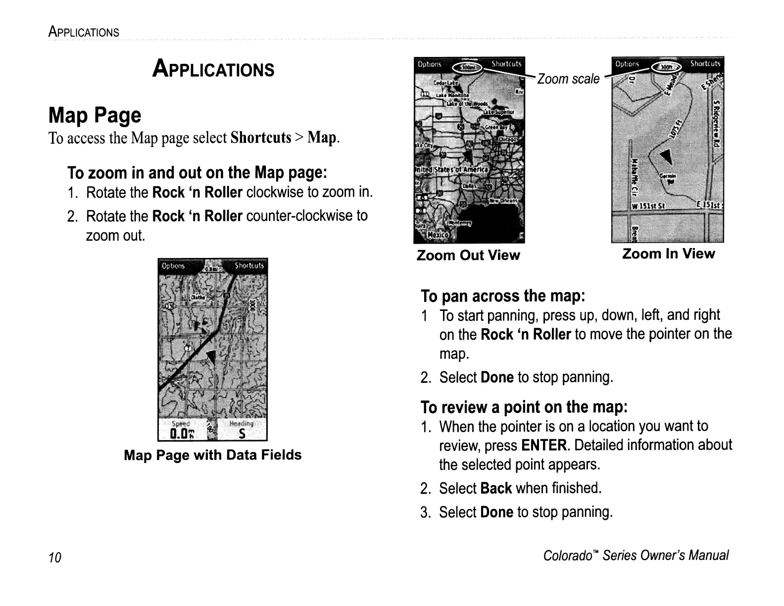
Map Page with Data Fields
Zoom Out View
Zoom
scale
Zoom
In
View
10
Colorado
TN
Series
Owner's
Manual
To
pan
across
the
map:
1
To
start
panning,
press
up,
down,
left,
and
right
on
the
Rock
'n
Roller
to
move
the
pointer
on
the
map.
2.
Select
Done
to
stop
panning.
To
review
a
point
on
the
map:
1.
When
the
pointer
is
on
a
location
you
want
to
review,
press
ENTER.
Detailed
information
about
the
selected
point
appears.
2.
Select
Back
when
finished.
3.
Select
Done
to
stop
panning.
ApPLICATIONS
ApPLICATIONS
Map
Page
To
access
the
Map
page
select
Shortcuts>
Map.
To
zoom
in
and
out
on
the
Map
page:
1.
Rotate
the
Rock
'n
Roller
clockwise
to
zoom
in.
2.
Rotate
the
Rock
'n
Roller
counter-clockwise
to
zoom
out.
Map Page with Data Fields
Zoom Out View
Zoom
scale
Zoom
In
View
10
Colorado
TN
Series
Owner's
Manual

Other manuals for Garmin Colorado Series

Questions and Answers:

Question and Answer IconNeed help?

Do you have a question about the Garmin Colorado Series and is the answer not in the manual?

Garmin Colorado Series Specifications

General IconGeneral
Battery LifeUp to 15 hours
Water RatingIPX7
High-sensitivity ReceiverYes
InterfaceUSB
Barometric AltimeterYes
Waypoints1000
Routes50
Track log10, 000 points, 20 saved tracks
Display TypeColor TFT
Battery Type2 AA batteries
Electronic CompassYes
MemoryInternal memory
Wireless connectivityYes (Colorado 400t/400i only, unit-to-unit)

Related product manuals