 Loading...
Do you have a question about the Garmin Colorado Series and is the answer not in the manual?
| Battery Life | Up to 15 hours |
|---|---|
| Water Rating | IPX7 |
| High-sensitivity Receiver | Yes |
| Interface | USB |
| Barometric Altimeter | Yes |
| Waypoints | 1000 |
| Routes | 50 |
| Track log | 10, 000 points, 20 saved tracks |
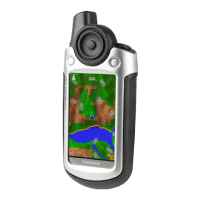
| Display Type | Color TFT |
| Battery Type | 2 AA batteries |
| Electronic Compass | Yes |
| Memory | Internal memory |
| Wireless connectivity | Yes (Colorado 400t/400i only, unit-to-unit) |