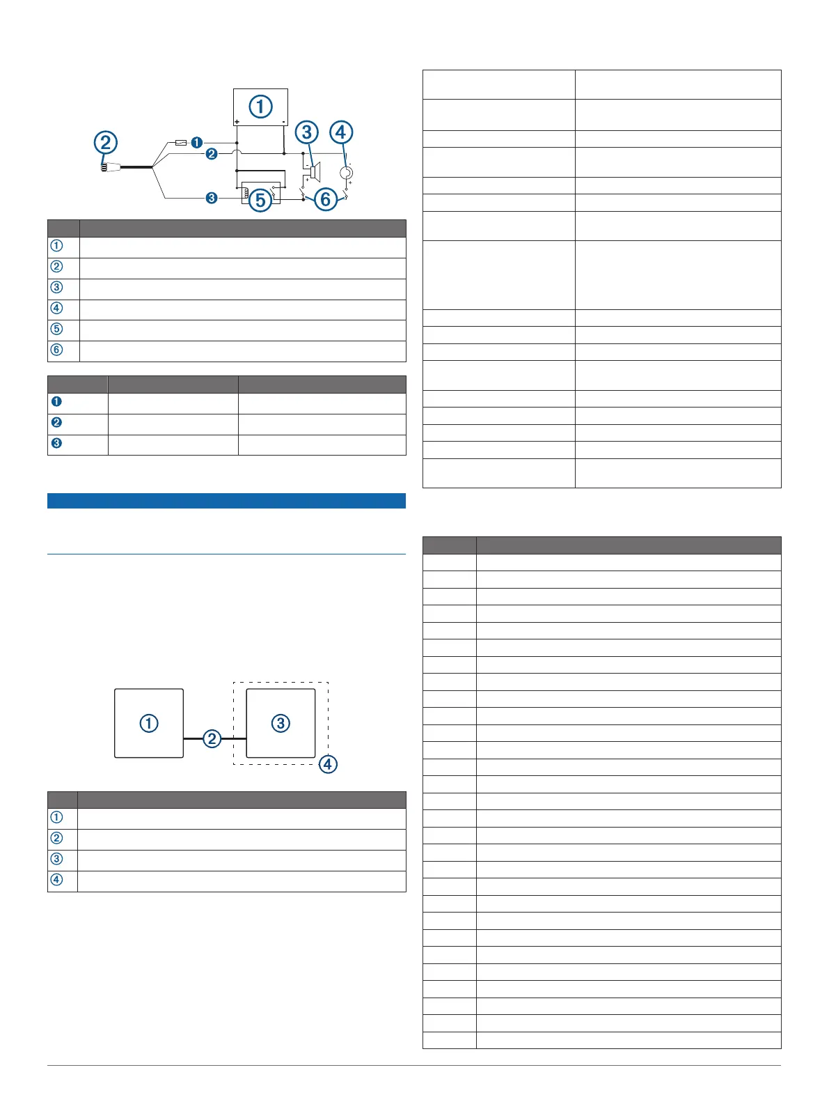
• To manually toggle visual and audible alerts, you can install
single-pole, single-throw switches.
Item Description
Power source
Power cable
Horn
Lamp
Relay (100 mA coil current)
Toggle switches to enable and disable lamp or horn alerts
Item Wire Color Wire Function
Red Power
Black Ground
Yellow Alarm
HDMI Out Video Considerations
NOTICE
To prevent corrosion due to moisture, you must use Garmin
GPSMAP accessory cables when connecting the chartplotter to
the video display. Using different cables voids your warranty.
Through the HDMI OUT port, you can duplicate the chartplotter
screen on another device, such as a television or monitor.
The Garmin GPSMAP HDMI accessory cable is 4.5 m (15 ft.)
long. If you need a longer cable, you should use an active HDMI
cable only. You need an HDMI coupler to connect the two HDMI
cables.
You must make all cable connections in a dry environment.
Item Description
GPSMAP 1222/1242 Touch chartplotter
GPSMAP HDMI cable (HDMI OUT)
Display with an HDMI In port, such as a computer or television
Dry environment, protected from moisture
Composite Video Considerations
This chartplotter allows video input from composite video
sources using the port labeled CVBS IN. When connecting
composite video, you should observe these considerations.
• The CVBS IN port uses a BNC connector. You can use a
BNC to RCA adapter to connect a composite-video source
with RCA connectors to the CVBS IN port.
• Video is shared across the Garmin Marine Network, but it is
not shared across the NMEA 2000 network.
Specifications
Dimensions (W × H × D) 33.0 × 22.6 × 7.9 cm (13.0 × 8.9 ×
3.1 in.)
Display size (W × H) 26.2 × 16.3 cm (10.3 × 6.4 in.)
12.1 in. diagonal
Weight 2.72 kg (6.0 lb.)
Clearance to nearest
obstruction
95 mm (3
3
/
4
in.)
Compass-safe distance 65 cm (25.6 in.)
Temperature range From -15° to 55°C (from 5° to 131°F)
Material Die-cast aluminum and polycarbonate
plastic
Water rating IEC 60529 IPX7
*The device withstands incidental
exposure to water of up to 1 m for up to
30 min. For more information, go to
www.garmin.com/waterrating.
Fuse 6 A, 125 V fast-acting
Input voltage From 10 to 32 Vdc
Max. power usage at 10 Vdc 36 W
Typical current draw at
12 Vdc
2.4 A
Max. current draw at 12 Vdc 3.0 A
NMEA 2000 LEN @ 9 Vdc 2
NMEA 2000 Draw 75 mA max.
Memory card 2 SD
®
card slots; 32 GB max. card size
Wireless frequency and
protocols
2.4 GHz @ 15.26 dBm
NMEA 2000 PGN Information
Transmit and Receive
PGN Description
059392 ISO acknowledgment
059904 ISO request
060160 ISO transport protocol: Data transfer
060416 ISO transport protocol: Connection management
060928 ISO address claimed
065240 Commanded address
126208 Request group function
126996 Product information
126998 Configuration information
127237 Heading/track control
127245 Rudder
127250 Vessel heading
127258 Magnetic variance
127488 Engine parameters: Rapid update
127489 Engine parameters: Dynamic
127493 Transmission parameters: Dynamic
127505 Fluid level
127508 Battery status
128259 Speed: Water referenced
128267 Water depth
129025 Position: Rapid update
129026 COG and SOG: Rapid update
129029 GNSS position data
129283 Cross track error
129284 Navigation data
129539 GNSS DOPs
129540 GNSS satellites in view
130060 Label
130306 Wind data
5
 Loading...