EasyManuals Logo

Garmin eTrex HC series User Manual

Garmin eTrex HC series
73 pages
To Next Page IconTo Next Page
To Previous Page IconTo Previous Page
Page #36 background imageLoading...
Page #36 background image
MAiN PAGES
Satellite
Page
This
page
appears
when
you
tum
the
unit
on
and
is
accessed
from
the
Main
Menu
thereafter.
Satellite Page Options
Use
With
GPS
Off/On-enables
you
to
tum
the
GPS
receiver
on
or
off.
Track
Up/North
Up-indicates
whether
satellites
are
shown
with
the
rings
oriented
with
North
toward
the
top
of
the
display
or
your
current
track
toward
the
top
of
the
screen.
Multicolor/Single Color-indicates
whether
each
satellite
appears
as
a
different
color.
New
Location-use if
you
have
moved
the
unit
more
than
600
miles
(1,000
km).
GPS
Elevation-shows
your
current
elevation.
24
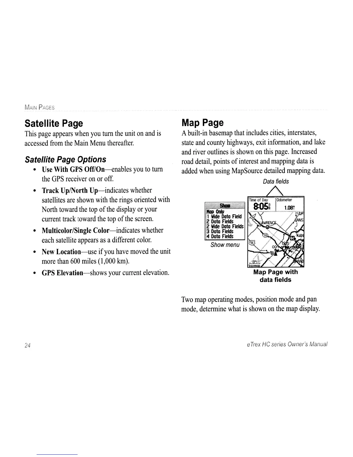
Map
Page
A
built-in
basemap
that
includes
cities,
interstates,
state
and
county
highways,
exit
information,
and
lake
and
river
outlines
is
shown
on
this
page.
Increased
road
detail,
points
of
interest
and
mapping
data
is
added
when
using
MapSource
detailed
mapping
data.
Data
fields
Map
1
Wide
Data
Field
2
Data
Fields
2
Wide
Data
Fields
3
Data
Fields
4
Data
Fields
v_.,
4>.
~
Show
menu
Map Page
with
data
fields
Two
map
operating
modes,
position
mode
and
pan
mode,
determine
what
is
shown
on
the
map
display.
e
Trex
He
series
Owner's
Manual

Other manuals for Garmin eTrex HC series

Questions and Answers:

Question and Answer IconNeed help?

Do you have a question about the Garmin eTrex HC series and is the answer not in the manual?

Garmin eTrex HC series Specifications

General IconGeneral
Resolution176 x 220 pixels
Battery Type2 AA batteries (not included)
Battery LifeUp to 25 hours
Water RatingIPX7
High-Sensitivity ReceiverYes
InterfaceUSB
CompassNo
Barometric AltimeterNo
Display TypeTFT
Track Log10, 000 points
BasemapWorldwide basemap

Related product manuals