68
GPSmap 76CS
GPS Navigation
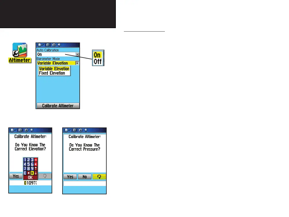
Altimeter Setup
Altimeter Setup
The Altimeter Setup Page allows you to setup the Altimeter to self
calibrate each time you turn on the unit, to function as a barometer or to
manually calibrate when you have accurate elevation or pressure data.
To setup the Altimeter:
1. Access the Altimeter Setup Page as explained at the beginning
of this section.
2. Highlight the Auto Calibration fi eld and press ENTER to select
from On or Off. When On, elevation is corrected by GPS.
3. Highlight the Barometer Mode fi eld and press ENTER to select
Variable Elevation (used when you are moving) or Fixed Eleva-
tion (used when you are stationary, allowing the Altimeter
to function as a standard barometer). Elevation trip data is not
recorded when in the Fixed Elevation mode.
To manually calibrate the Altimeter:
1. Highlight the “Calibrate Altimeter” button and press ENTER
to display the Calibrate Altimeter Page. You can calibrate the
Altimeter using one of three methods:
Enter the correct elevation: this requires a reliable source
for determining the elevation for your current location. Topo-
graphic maps, scientifi c altimeters, moving to a location where
the elevation is known, etc. can be used.
Enter the correct pressure: this requires a reliable source
for determining the accurate barometric pressure at your cur-
rent location. Scientifi c barometer, data from a weather station
in proximity to your location, etc.
Enter the correct
elevation
Enter the correct
barometric pressure
GPSmap 76CS Owner's Guide copy.indd 68 3/30/2004, 1:59:47 PM

 Loading...