Section 2 - On the Water
Page 30 90-8M0093150 eng MAY 2014
Track Waypoint
!
WARNING
Avoid serious injury or death. Inattentive boat operation can result in a collision with other watercraft, obstacles, swimmers, or
underwater terrain. The autopilot navigates a preset course, and does not automatically respond to hazards in the vicinity of
the boat. The operator must stay at the helm, ready to evade hazards and warn passengers of course changes.
Track waypoint allows the boat to automatically navigate to a specific waypoint or sequence of waypoints, called a waypoint
route. This feature is intended for use in open waters, free from obstructions above and below the waterline.
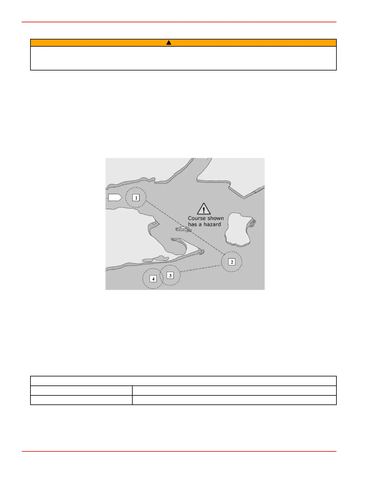
Using the example route shown in the following illustration:
• Waypoints are shown in numbered squares within the arrival circle (a dashed‑line circle around the numbered square).
• A hazard is present between waypoints 1 and 2. If these waypoints are used for the route, the autopilot will attempt to
navigate through the hazard. It is the captain's responsibility to select waypoints that avoid all hazards.
• Waypoint 4 is too close to 3 to be used in the same route. Waypoints must be far enough apart that the arrival circles do
not intersect.
• A route, including waypoints 1, 2, and 3, is represented by the straight dashed‑line. The autopilot system will attempt to
navigate this route. It is the responsibility of the captain to ensure that the route does not contain any hazards, and to keep
watch while underway.
Example route
When the track waypoint feature is activated and the boat is put into operation:
• The operator must remain at the helm at all times. The feature is not designed to allow unattended operation of the vessel.
• Do not use track waypoint as the sole source of navigation.
IMPORTANT: Track waypoint can be used only with chartplotters approved by Mercury Marine.
Waypoint data needs to be provided to VesselView by a third‑party chartplotter. The arrival radius must be set to 0.05 nautical
miles or less. Refer to the chartplotter's user manual for details.
The accuracy of the feature can be affected by environmental conditions and incorrect use. Observe the following information
when using the track waypoint and waypoint sequencing feature.
Waypoint data—distance settings
Between waypoints Greater than 1.0 nautical mile (1.15 mile)
Arrival alarms No less than 0.1 nautical mile (0.12 mile)
Engaging Track Waypoint Mode
To engage the track waypoint mode:
1. Turn on the chartplotter and select a single waypoint or waypoint route to be tracked.
2. Place at least one ERC lever in forward gear. Track waypoint does not function if both levers are in neutral or reverse.
 Loading...