EasyManua.ls Logo

Garmin GPSMAP 400 User Manual

Garmin GPSMAP 400
72 pages
To Next Page IconTo Next Page
To Previous Page IconTo Previous Page
Page #44 background imageLoading...
Page #44 background image
38 GPSMAP
®
400 Series Owner’s Manual
uSInG Sonar
Scroll Speed—adjust the rate at which the sonar scrolls from
right to left (Ultrascroll, Fast, Medium, or Slow). If using a
speed-capable transducer, select Auto to have the scroll speed
automatically adjust to your boat’s water speed.
Surface Noise—show or hide the sonar returns near the surface of
the water. Hide surface noise to help reduce clutter.
Whiteline—highlights the strongest signal from the bottom to help
identify its hardness or softness.
Off—(default) Whiteline is disabled.
High—the most sensitive setting. Almost all strong returns
are highlighted in white.
Medium—many strong returns are highlighted in white.
Low—the least sensitive setting. Only the strongest returns
are highlighted in white.
Numbers—show or hide battery voltage, water temperature, water
speed (if your transducer is capable), cruising, and navigation.
NOTE: To show water temperature or water speed, change the
setting to Auto. If the connected transducer is capable, the data
is shown.
Advanced Sonar Settings
To adjust advanced sonar settings, press MENU while viewing a
sonar screen.
Range—the range of the depth scale on the right side of the screen
(Auto or Manual Range).
Gain—controls the sensitivity of the sonar receiver (Auto or
Manual Gain). To see more detail, increase the Gain. If the screen
is cluttered, decrease the Gain.
Beam
—when using a dual beam transducer, select a Wide or
Narrow beam.
Frequency—when using a dual frequency transducer, select how
the frequencies appear on screen (200kHz, 50kHz, Dual, or Auto).
Zoom—zoom in to a section of the Full Screen. The zoom is off, or
set to No Zoom by default. Four options are available:
2x Zoom—twicethemagnication.
4x Zoom—fourtimesthemagnication.
Bottom Lock
—locks the zoom window to the bottom.
Split Zoom—opens the Split Zoom screen.
Depth Line—quicklyreferenceaspecicdepth(On or Off).
A-Scope—(dual frequency only) averticalasheralongtheright
side of the screen (On or Off).

Table of Contents

Other manuals for Garmin GPSMAP 400

Question and Answer IconNeed help?

Do you have a question about the Garmin GPSMAP 400 and is the answer not in the manual?

Garmin GPSMAP 400 Specifications

General IconGeneral
Weight1.5 lbs (680 grams)
Waterproof RatingIPX7
Routes100
Track log10, 000 points, 200 saved tracks
Map DataBlueChart g2
ReceiverHigh-sensitivity GPS
Waypoints/favorites/locations3000
Preloaded mapsYes
Waypoints3000
InterfaceNMEA 0183

Summary

Warnings

General Safety Warnings

Potentially hazardous situations and navigation safety advice.

Important Information

Product Information and Disclaimers

Information on map data, California recycling act, and product warnings.

GETTING STARTED

Turning the Unit On or Off

Instructions for powering the device on and off, including initial setup.

Acquiring GPS Satellite Signals

Process for the unit to establish its current location via GPS satellites.

USING CHARTS

Navigation Chart

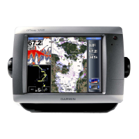
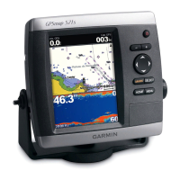
Displays navigation data like buoys, depth soundings, and marinas.

WHERE TO?

Navigating to a Destination

Searching for and navigating to nearby destinations like fuel, marinas, and waypoints.

Creating and Using Waypoints

Storing and managing up to 1,500 alphanumeric points of interest.

Creating and Using Routes

Planning and storing routes with up to 250 waypoints each.

CONFIGURING THE UNIT

Configuring System Settings

Adjusting general system parameters like language, beeper, and display.

Setting Alarms

Configuring audible alarms for navigation, system, sonar, and weather conditions.

USING SONAR

Setting Up Sonar

Configuring universal sonar settings like color scheme and fish symbols.

INSTALLING THE UNIT

Selecting an Installation Location

Considerations for choosing the optimal mounting spot for the unit.

Mounting the Unit

Instructions for surface or flush mounting the unit using the bracket.

Installing the Transducer

Guides for assembling and mounting the transducer on the boat.

Installing the Wiring Harness

Connecting the unit to the power source and other devices.

Testing the Installation

Procedures for powering on the unit and performing initial configuration and checks.

Related product manuals