About assisted GPS (A-GPS)
Your device supports A-GPS (network
service). When you activate A-GPS, your
device receives useful satellite
information from an assistance data
server over the cellular network. With the
help of assisted data, your device can
obtain the GPS position faster.
Assisted GPS (A-GPS) is used to retrieve
assistance data over a packet data
connection, which assists in calculating
the coordinates of your current location
when your device is receiving signals from
satellites.
Your device is preconfigured to use the
Nokia A-GPS service, if no service provider-
specific A-GPS settings are available. The
assistance data is retrieved from the Nokia
A-GPS service server only when needed.
You must have an internet access point
defined in the device to retrieve
assistance data from the Nokia A-GPS
service over a packet data connection.
Define an access point for A-GPS
Select Menu > Applications > Location
and Positioning > Positioning server >
Access point. Only a packet data internet
access point can be used for this service.
Your device asks for the internet access
point when GPS is used for the first time.
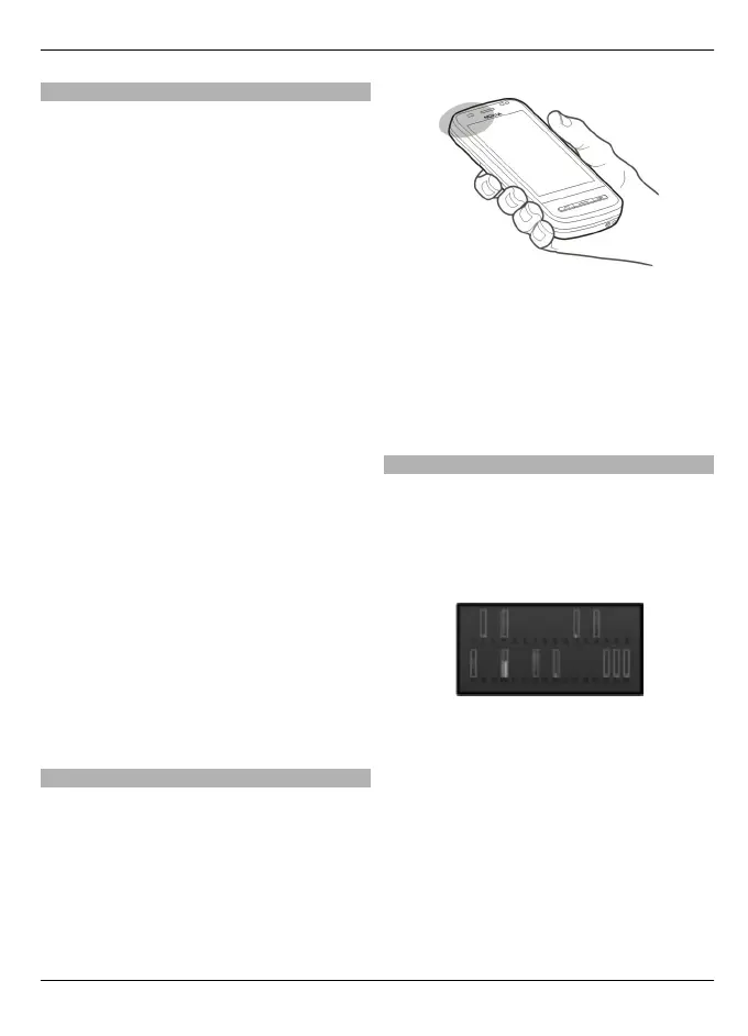
Hold your device correctly
When using the GPS receiver, ensure you
do not cover the antenna with your hand.
Establishing a GPS connection may take
from a couple of seconds to several
minutes. Establishing a GPS connection in
a vehicle may take longer.
The GPS receiver draws its power from the
device battery. Using the GPS receiver may
drain the battery faster.
Tips on creating a GPS connection
Check the satellite signal status
Select Menu > Applications > Location
and GPS data > Options > Satellite
status.
If your device has found satellites, a bar
for each satellite is shown in the satellite
info view. The longer the bar, the stronger
the satellite signal. When your device has
received enough data from the satellite
signal to calculate your location, the bar
colour changes.
Initially your device must receive signals
from at least four satellites to be able to
calculate your location. When the initial
calculation has been made, it may be
Positioning (GPS) 69
© 2010 Nokia. All rights reserved.
 Loading...