Editing and Reordering Locations in a Trip
1
Select > Trip Planner > Saved Trips.
2
Select a saved trip.
3
Select a location.
4
Select an option:
• To move the location up or down, select , and drag the
location to a new position in the trip.
• To add a new location after the selected location, select
.
• To remove the location, select .
Optimizing the Order of Destinations in a Trip
The device can automatically optimize the order of destinations
in your trip to create a shorter, more efficient route. The starting
location and final destination are not changed when you
optimize the order.
While editing a trip, select > Optimize Order.
Discovering Attractions Along Your Trip
The device can suggest interesting or popular attractions to add
to your trip.
1
While editing a trip, select > Trip Settings > Suggest
Attractions.
2
Select an attraction to view more information.
3
Select Select to add the attraction to your trip.
Changing Routing Options for a Trip
You can customize how the device calculates the route when
you start your trip.
1
Select > Trip Planner > Saved Trips.
2
Select a saved trip.
3
Select the vehicle profile icon, and select the vehicle you plan
to use while navigating the trip (optional).
4
Select > Trip Settings.
5
Select an option:
• To add shaping points to your trip, select Shape Route,
and follow the on-screen instructions (Shaping Your
Route, page 5).
• To change the calculation mode for the trip, select Route
Preference (Changing the Route Calculation Mode,
page 5).
Navigating to a Saved Trip
Before you can start navigating a saved trip, the active vehicle
profile on the device must match the selected vehicle profile for
the trip (Changing Routing Options for a Trip, page 22). If it does
not match, the device prompts you to change the vehicle profile
before you can start the trip (Switching the Vehicle Profile,
page 3).
1
Select > Trip Planner > Saved Trips.
2
Select a saved trip.
3
Select Go!.
4
Select the first location to navigate to, and select Start.
The device calculates a route from your current location to
the selected location, and then it guides you to the remaining
trip destinations in order.
Editing and Saving Your Active Route
If a route is active, you can use the trip planner to edit and save
your route as a trip.
1
Select > Trip Planner > My Active Route.
2
Edit your route using any of the trip planner features.
The route recalculates each time you make a change.
3
Select Save to save your route as a trip, which you can
navigate again later (optional).
Viewing Previous Routes and Destinations
Before you can use this feature, you must enable the travel
history feature (Device Settings, page 24).
You can view your previous routes and places you have stopped
on the map.
Select > Where I've Been.
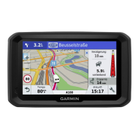
Viewing the Weather Forecast
Before you can use this feature, your device must be receiving
weather data. You can connect your device to the Smartphone
Link app to receive weather data. If your device is connected to
a power cable compatible with digital traffic signals, your device
can receive area weather information from an over-the-air
signal. In some areas, weather information may be received
from FM radio stations using HD Radio
™
technology (Traffic,
page 14).
NOTE: Weather forecasts are not available in all areas.
1
Select > Weather.
The device shows the current weather conditions and a
forecast for the next several days.
2
Select a day.
The detailed forecast for that day appears.
Viewing Weather Near a Different City
1
Select > Weather > Current Location.
2
Select an option:
• To view weather for a favorite city, select a city in the list.
• To add a favorite city, select Add City, and enter a city
name.
dēzl Settings
Navigation Settings
Select > Navigation.
Vehicle Profile: Sets the vehicle profile for each truck with
which you will use your device.
Map & Vehicle: Sets the map detail level and the vehicle icon to
display on your device.
Route Preferences: Sets the route preferences when
navigating.
Driver Assistance: Sets driver assistance alerts.
Traffic: Sets the traffic details the device uses. You can set your
device to avoid traffic when calculating routes, and to find a
new route to your destination if a traffic delay occurs
(Avoiding Traffic Delays on Your Route, page 6).
Units: Sets the unit of measure used for distances.
Map and Vehicle Settings
Select > Navigation > Map & Vehicle.
Vehicle: Sets the vehicle icon that represents your position on
the map.
Driving Map View: Sets the perspective on the map.
Map Detail: Sets the level of detail on the map. More detail may
cause the map to draw slower.
Map Theme: Changes the color of the map data.
Map Tools: Sets the shortcuts that appear in the map tools
menu.
Map Layers: Sets the data that appears on the map page
(Customizing the Map Layers, page 11).
Auto Zoom: Automatically selects the zoom level for optimal
use of your map. When disabled, you must zoom in or out
manually.
myMaps: Sets which installed maps the device uses.
22 dēzl Settings
 Loading...