Garmin G1000 Pilot’s Guide for the Piper PA-32 Saratoga
190-02692-00 Rev. A
312
HAZARD AVOIDANCE
SYSTEM
OVERVIEW
FLIGHT
INSTRUMENTS
EIS
AUDIO PANEL
& CNS
FLIGHT
MANAGEMENT
HAZARD
AVOIDANCE
AFCS
ADDITIONAL
FEATURES
APPENDICESINDEX
DISPLAYING TERRAIN PROXIMITY DATA
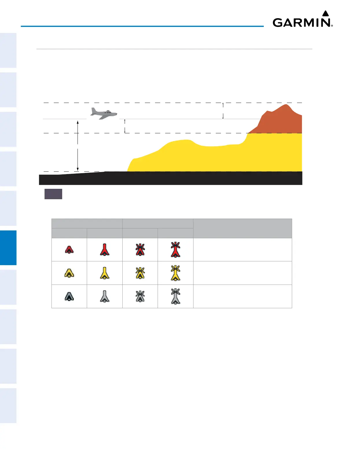
The MAP - TERRAIN PROXIMITY Page is the principal page for viewing terrain and obstacle information.
The system uses the symbols and colors in the following figure and table to represent obstacles and aircraft
altitude on the MAP - TERRAIN PROXIMITY Page. Terrain Proximity uses black, yellow, and red to represent
terrain information relative to aircraft altitude. The color of each obstacle is associated with the altitude of the
aircraft.
1000 ft
Aircraft Altitude
100 ft Threshold
Terrain Above Aircraft Altitude
Red terrain is above
or within 100 ft below
the aircraft altitude
Yellow terrain is between 100 ft and 1000 ft below the aircraft altitude
Black terrain is more than 1000 ft below the aircraft altitude
On the Terrain Proxmity Page only, a gray shade of purple indicates no terrain data is
Figure 6-53 Terrain Altitude/Color Correlation for Terrain Proximity
Unlighted Obstacle Lighted Obstacle
Obstacle Location
< 1000’ AGL > 1000’ AGL < 1000’ AGL > 1000’ AGL
Red obstacle is above or within 100 ft
below the aircraft altitude
Yellow obstacle is between 100 ft and
1000 ft below the aircraft altitude
Gray obstacle* is more than 1000 ft below
aircraft altitude
* Gray obstacles not shown on the Terrain Proximity- Page.
Table 6-8 Terrain Proximity Obstacle Colors and Symbology
Display of terrain and obstacle information is available as an additional reference on the following maps and
pages:
» PFD Inset Map
» MAP - NAVIGATION MAP Page
» Flight Plan Page
» Trip Planning Page

 Loading...