EasyManuals Logo

Garmin GPSMAP 62 User Manual

Garmin GPSMAP 62
154 pages
To Next Page IconTo Next Page
To Previous Page IconTo Previous Page
Page #126 background imageLoading...
Page #126 background image
Menyesuaikan Perangkat
124 Panduan Pengguna GPSMAP 62/62s
IND
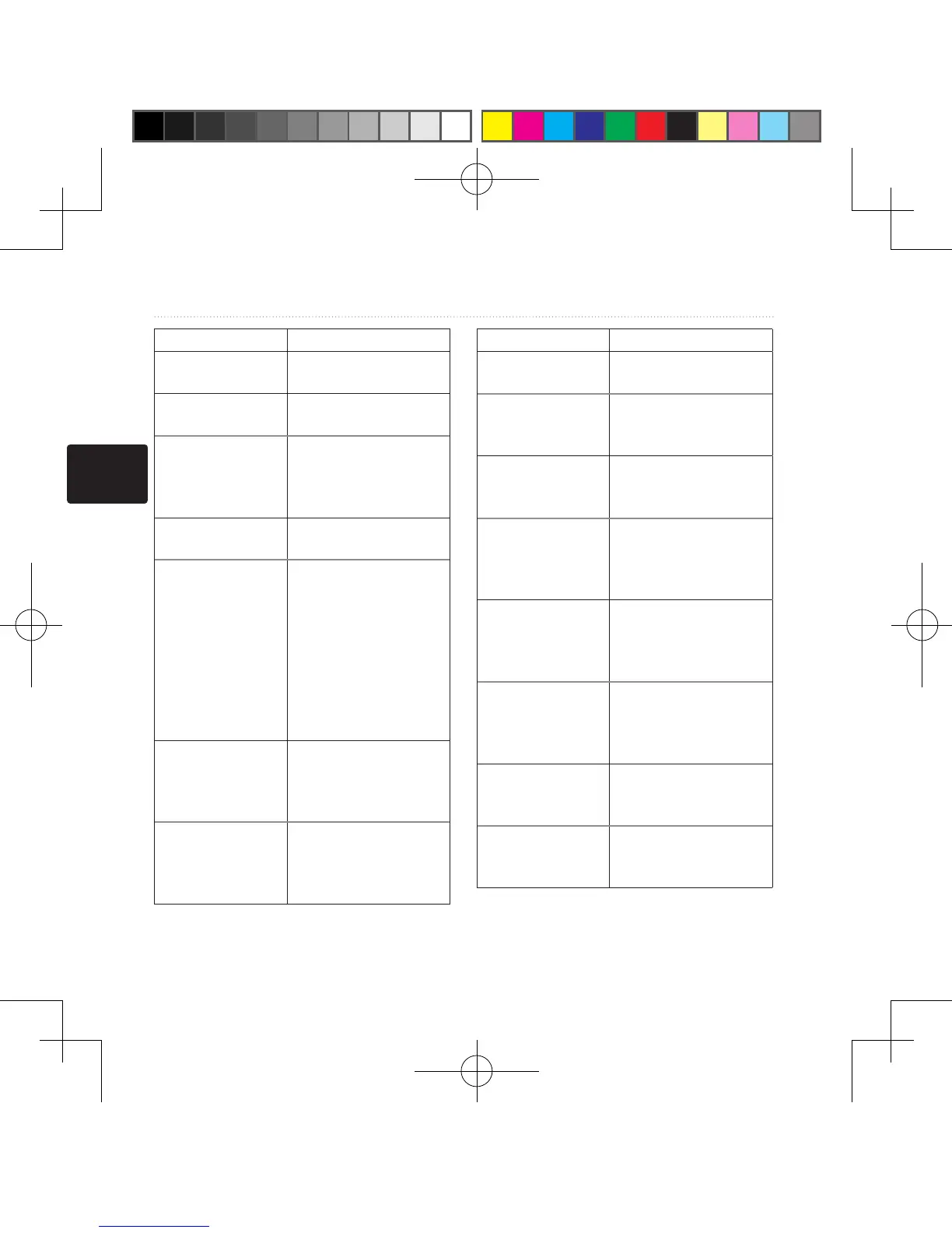
Kolom Data Keterangan
Battery Level
(Tingkat Baterai)
Daya baterai yang
tersisa�
Bearing (Arah) Arah dari lokasi Anda
saat itu ke tujuan�
**Cadence
(Siklus)
(diperlukan
aksesori siklus)
Perputaran poros
roda atau langkah per
menit�
Course (Haluan) Arah dari lokasi awal
Anda ke tujuan�
Depth
(Kedalaman)
Kedalaman air
Memerlukan
sambungan ke
perangkat NMEA 0183
yang mendukung
pengukuran
kedalaman untuk
memperoleh data
(halaman 128 )�
**Descent
- Average
(Menurun - Rata-
Rata)
Jarak menurun vertikal
rata-rata�
**Descent
- Maximum
(Menanjak -
Maksimum)
Kecepatan menurun
maksimum dalam kaki/
meter per menit�
Kolom Data Keterangan
**Descent - Total
(Menurun - Total)
Jarak menurun total
yang ditempuh�
Distance to
Dest� (Jarak ke
Destinasi)
Jarak ke tujuan akhir
Anda�
Distance to
Next (Jarak ke
Berikutnya)
Sisa jarak ke titik
acuan berikutnya pada
rute�
Elevation
(Ketinggian)
Ketinggian lokasi Anda
saat itu di atas atau
di bawah permukaan
laut�
**Elevation
- Maximum
(Ketinggian -
Maksimum)
Ketinggian maksimum
yang dicapai�
**Elevation
- Minimum
(Ketinggian -
Minimum)
Ketinggian minimum
yang dicapai�
ETA at
Destination (ETA
di Destinasi)
Perkiraan waktu tiba di
tujuan akhir
ETA at Next (ETA
di Berikutnya)
Perkiraan waktu tiba di
titik acuan berikutnya
pada rute�
190-01215-25_0A.indd 124 2011/3/22 下午 03:13:11

Table of Contents

Other manuals for Garmin GPSMAP 62

Questions and Answers:

Question and Answer IconNeed help?

Do you have a question about the Garmin GPSMAP 62 and is the answer not in the manual?

Garmin GPSMAP 62 Specifications

General IconGeneral
Display resolution160 x 240 pixels
Display typetransflective, 65-K color TFT
Battery type2 AA batteries (not included); NiMH or Lithium recommended
Battery life20 hours
Water ratingIPX7
High-sensitivity receiverYes
InterfaceUSB
BasemapYes
Ability to add mapsYes
Built-in memory1.7 GB
Accepts data cardsmicroSD card (not included)
Waypoints/favorites/locations2000
Routes200
Track log10, 000 points, 200 saved tracks
Electronic compassYes
Barometric altimeterYes
Geocaching-friendlyYes (Paperless)
Custom maps compatibleYes
Picture viewerYes
Garmin Connect compatibleYes
Wireless connectivityNo
GPS receiverYes
Display size2.6 inches
Weight260.1 g with batteries
Physical dimensions6.1 x 16.0 x 3.6 cm

Related product manuals