EasyManuals Logo

Garmin GPSMAP 62 User Manual

Garmin GPSMAP 62
154 pages
To Next Page IconTo Next Page
To Previous Page IconTo Previous Page
Page #27 background imageLoading...
Page #27 background image
GPSMAP 62/62s Owner’s Manual 25
Customizing Your Device
EN
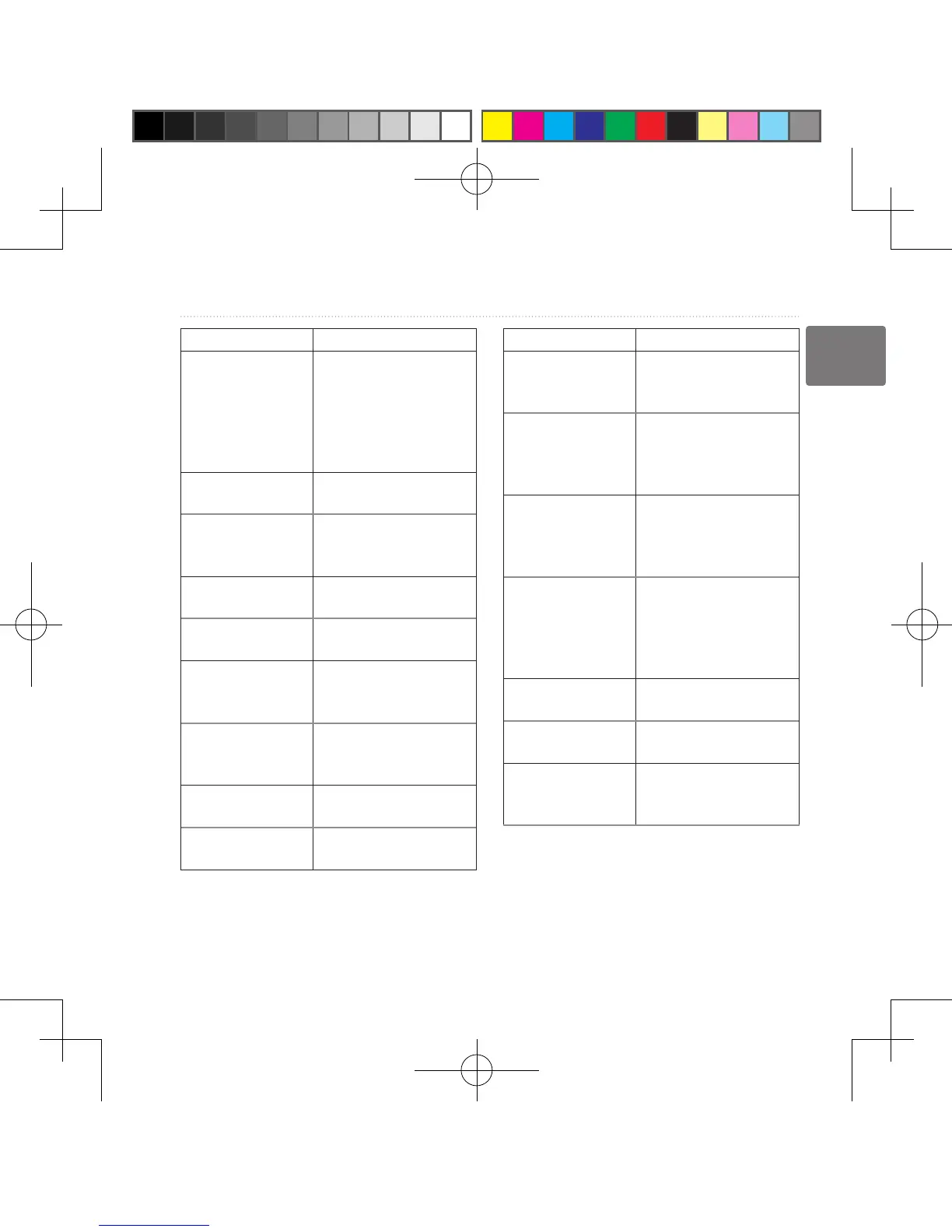
Data Field Description
Depth The depth of the water
Requires a connection
to a NMEA 0183
depth-capable device
to acquire data
(page 28)�
**Descent -
Average
The average vertical
distance of descent�
**Descent -
Maximum
The maximum descent
rate in feet/meter per
minute�
**Descent - Total The total elevation
distance descended�
Distance to Dest� The distance to your
nal destination.
Distance to Next The remaining
distance to the next
waypoint on the route�
Elevation The altitude of your
current location above
or below sea level�
**Elevation -
Maximum
The highest elevation
reached�
**Elevation -
Minimum
The lowest elevation
reached�
Data Field Description
ETA at Destination The estimated time of
day you will reach your
nal destination.
ETA at Next The estimated time of
day you will reach the
next waypoint on the
route�
Glide Ratio The ratio of horizontal
distance traveled to
the change in vertical
distance�
Glide Ratio To
Dest�
The glide ratio required
to descend from
your current position
and elevation to the
destination elevation�
GPS Signal
Strength
The strength of the
GPS signal�
Heading The direction you are
moving�
**Heart Rate
(heart rate monitor
required)
Your heart rate in beats
per minute (bpm)�
190-01215-25_0A.indd 25 2011/3/22 下午 03:12:42

Table of Contents

Other manuals for Garmin GPSMAP 62

Questions and Answers:

Question and Answer IconNeed help?

Do you have a question about the Garmin GPSMAP 62 and is the answer not in the manual?

Garmin GPSMAP 62 Specifications

General IconGeneral
Display resolution160 x 240 pixels
Display typetransflective, 65-K color TFT
Battery type2 AA batteries (not included); NiMH or Lithium recommended
Battery life20 hours
Water ratingIPX7
High-sensitivity receiverYes
InterfaceUSB
BasemapYes
Ability to add mapsYes
Built-in memory1.7 GB
Accepts data cardsmicroSD card (not included)
Waypoints/favorites/locations2000
Routes200
Track log10, 000 points, 200 saved tracks
Electronic compassYes
Barometric altimeterYes
Geocaching-friendlyYes (Paperless)
Custom maps compatibleYes
Picture viewerYes
Garmin Connect compatibleYes
Wireless connectivityNo
GPS receiverYes
Display size2.6 inches
Weight260.1 g with batteries
Physical dimensions6.1 x 16.0 x 3.6 cm

Related product manuals