190-01639-00 GSU 75 ADAHRS Installation Manual
Rev. 6 Page 1-2
1.2 Equipment Description
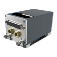
1.2.1 GSU 75
The Garmin GSU 75 ADAHRS (Air Data, Attitude and Heading Reference System) is a remote mounted
device that provides flight altitude, airspeed, attitude and heading data for flight instrumentation.
The GSU 75 provides the following information in ARINC 429 format:
• Aircraft Altitude and Airspeed
• Aircraft Vertical Speed, Mach, and Air Temperature
• Aircraft Heading, Pitch, and Roll
• Aircraft Yaw, Pitch, and Roll rates
• Aircraft Body-axis Accelerations
• Rates of Change of Heading, Pitch, and Roll
• Aircraft Accelerations Expressed in a Local Level Frame of Reference
• Density Altitude
• Pressure Altitude
• Indicated Airspeed
• True Airspeed
Operating voltage is 14/28 volts DC. The GSU 75 also provides the operating current to the GTP 59 OAT
Probe and operating voltage to the GMU 44 Magnetometer.
The GSU 75/GMU 44 is capable of maneuvers through a range of 360° in bank and pitch. The rotation
rate capability is ± 250 °/s. However, ARINC 429 angular rate output messages are limited to ±128° per
second.
Bank error and pitch error are within 1.0° in static conditions and +/- 2.5° under dynamic and flight
conditions. Heading accuracy is within +/- 2.0° in static conditions and +/- 6.0° in dynamic and flight
conditions.
Operation in the following regions is not authorized due to unsuitability of the magnetic fields near the
Earth’s poles:
1. North of 72° North latitude at all longitudes
2. South of 70° South latitude at all longitudes
3. North of 65° North latitude between longitude 75° W and 120° W. (Northern Canada)
4. North of 70° North latitude between longitude 70° W and 128° W. (Northern Canada)
5. North of 70° North latitude between longitude 85° E and 114° E. (Northern Russia)
6. South of 55° South latitude between longitude 120° E and 165° E. (Region south of Australia and
New Zealand)
1.2.2 GMU 44
The Garmin GMU 44 Magnetometer is a remote mounted device that provides magnetic information to
support the function of the GSU 75. The GSU 75 provides operating voltage to the GMU 44
Magnetometer.
The document reference is online, please check the correspondence between the online documentation and the printed version.
 Loading...