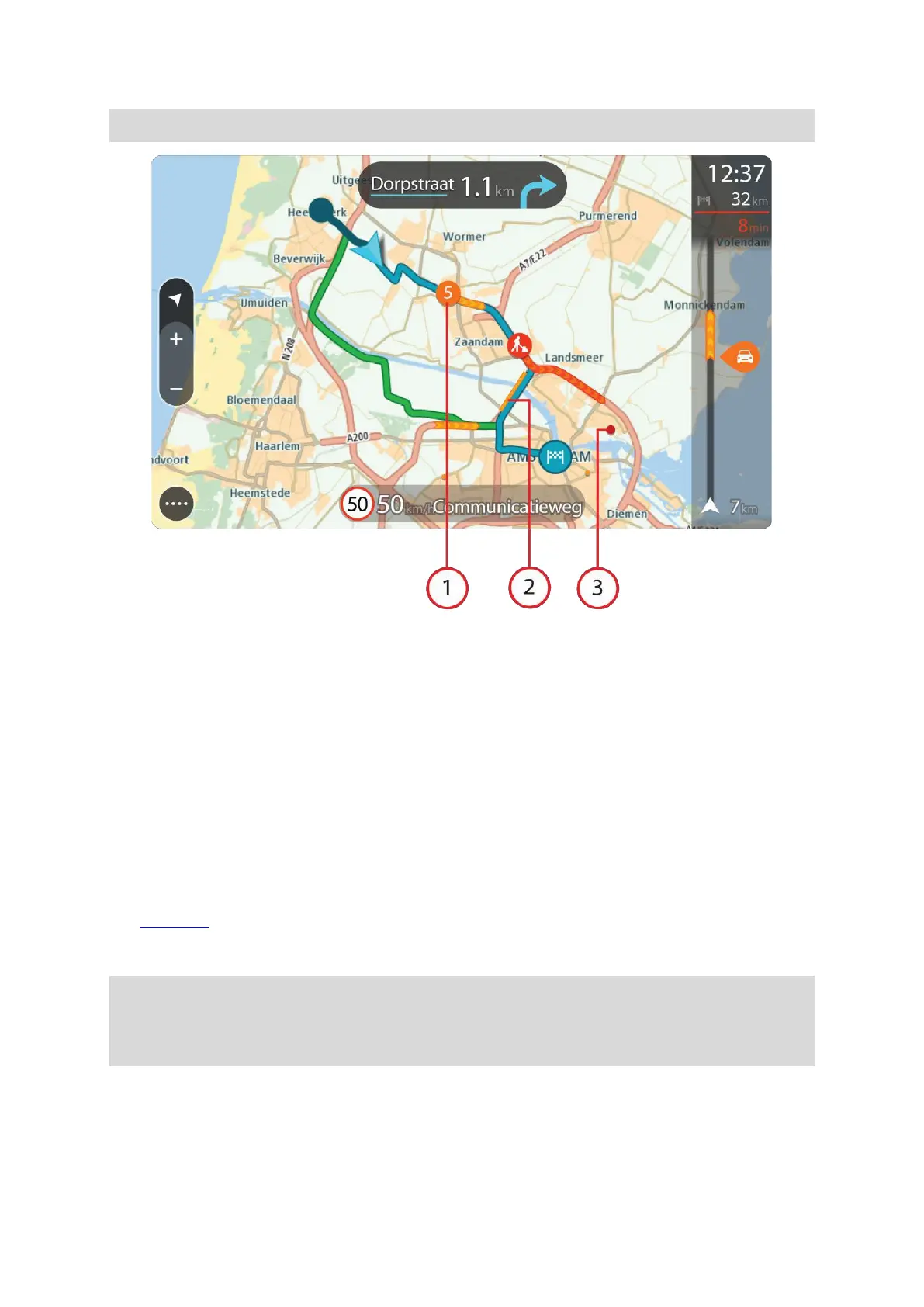
EasyManuals Logo

TomTom GO CLASSIC User Manual

TomTom GO CLASSIC
153 pages
To Next Page IconTo Next Page
To Previous Page IconTo Previous Page
Page #34 background image
34
1.
Traffic incident that affects your route in your direction of travel.
A symbol or number at the start of the incident shows the type of incident or the delay in
minutes, f
or example 5 minutes.
The colour of the incident indicates the speed of traffic relative to the maximum allowed speed
at tha
t location, with red being the slowest. The stripes on the traffic jam are also animated to
show the
speed of the traffic, where appropriate.
For a complete list of incident types, see Traffic incidents.
2.
Traffic incident on your route but in the opposite direction of travel.
3.
Traffic incidents on roads that are not visible at your current zoom level.
Looking at traffic on your route
Information about traffic incidents on your route is shown in the route bar on the right-hand side of
the map and guidance views.
The route bar
tells you about traffic delays while you are driving, using symbols to show you where
each traffic incident is located on your route. When using the map view, you can also select symbols
on the map itself.
Note: If your TomTom GO CLASSIC isn't receiving any traffic information, a symbol showing
traffic
with a cross appears underneath the arrival information panel.
Note: To make the route bar more readable some incidents may not be shown. These incidents
will always be of minor importance and only cause short delays.
Tip: Select an incident on the map to see more detailed information.

Table of Contents

Questions and Answers:

Question and Answer IconNeed help?

Do you have a question about the TomTom GO CLASSIC and is the answer not in the manual?

TomTom GO CLASSIC Specifications

General IconGeneral
Display diagonal5 \
Touch technologyMulti-touch
Display resolution480 x 272 pixels
Placement supportedHorizontal/Vertical
Spoken languages- Afrikaans - Arabic - Australian English - Bulgarian - Catalan - Croatian - Czech - Danish - Dutch - Dutch Belgium - Finnish - French - German - Greek - Hungarian - Irish English - Italian - Lithuanian - New Zealand English - Norwegian - Polish - Portuguese - Portuguese Brazil - Serbian - Slovenian - Spanish - Spanish (Latin American) - Spanish Argentina/Latin - Spanish Chile - Swedish - Turkish - UK English - US English
Languages supportMulti
Traffic Message Channel (TMC)-
Cables includedUSB
Marine (chartplotters, sounders)No
Battery typeBuilt-in
Power source typeBattery
Battery life (max)1 h
Storage media typeFlash
Compatible memory cardsMicroSD (TransFlash)
Included memory card size32 GB
Internal storage capacity16 GB
Form factorFixed
Product colorBlack
Map coverageAll Europe
Weight and Dimensions IconWeight and Dimensions
Depth23.8 mm
Width162.5 mm
Height104.8 mm
Weight201 g

Related product manuals