GTX 330/330D Installation Manual 190-00207-02
Page 1-4 Rev. U
1.4 TIS System Capabilities
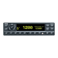
The GTX 330 also provides uplink information such as Traffic Information Service (TIS). TIS is a
ground-based service providing relative location of all transponder equipped aircraft within a specified
service volume. The TIS ground sensor uses real time track reports to generate traffic notification. TIS
provides a graphic display of traffic advisory information in the cockpit for non-TCAS equipped aircraft.
Advisory traffic information is available to aircraft equipped with a Mode S data link such as the Garmin
GTX 330 transponder. Advisory traffic information may be displayed on a Garmin 400/500 Series unit.
The GTX 330 unit can also be incorporated in installations with other compatible control/display units
such as the Garmin GNS 480 (CNX80), GTN 6XX/7XX, and GMX 200 (MX20) Multifunction Display
(MFD).
Surveillance data includes all transponder equipped aircraft within the coverage volume. Aircraft without
an operating transponder are invisible to TIS. TIS displays traffic within seven nautical miles from 3000
feet below to 3500 feet above the requesting aircraft. The pilot sees the location, relative direction and
altitude of other aircraft.
1.5 Mutual Suppression Pulses
Other equipment on board the aircraft may transmit in the same frequency band as the transponder, such as
DME or another transponder. Mutual suppression is a synchronous pulse that is sent to the other
equipment to suppress transmission of a competing transmitter for the duration of the pulse train
transmission. The transponder transmission may be suppressed by an external source and other equipment
on board may be suppressed by the transponder. This feature is designed to limit mutual interference.
 Loading...