2 Description of the System
2.1 System Components
Component Description
Instrument To calculate a position from the computed ranges to all
visible GNSS (Global Navigation Satellite System) satel-
lites.
To estimate a tilt compensated pole tip position by com-
bining the GNSS position with attitude information from
an Inertial Measurement Unit (IMU).
To capture image groups with the camera and to use
those captured images to calculate the 3D coordinates
of points.
Web server Web-based tool to preprogram the GNSS instrument.
Antenna To receive the satellite signals from the GNSS satellites.
Leica Innity The ofce software including a series of help programs
which support working with Leica instruments.
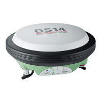
Instrument Description
GS18 GPS, GLONASS, BeiDou and Galileo GNSS receiver, QZSS,
NavIC L5, SBAS (EGNOS, WAAS, MSAS, GAGAN), L-band,
multi-frequency, code and phase, real-time capable,
internal memory, integrated Inertial Measurement Unit
and camera.
2.2 System Concept
2.2.1 Software Concept
All instruments use the same software concept.
Software type Description
GS rmware
(GS_xx.fw)
This software covers all functions of the instrument.
The Web server application is integrated into the rm-
ware and cannot be deleted.
The English language is integrated into the rmware and
cannot be deleted.
Language soft-
ware
(WEB_LANG.sxx)
Numerous languages are available for the Web server
application.
The English language is the default language. One lan-
guage is chosen as the active language.
☞
Uploading GS rmware can take some time. Ensure that the battery is
at least 75% full before beginning the upload, and do not remove the
battery during the upload process.
Main components
Instrument
Description
Software for all GS
GNSS instruments
Software upload
16 Description of the System

 Loading...