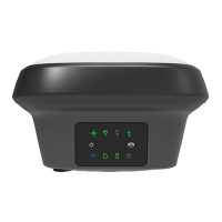
LED LED Status Status of the Instrument
fast ashing
red
SD card is inserted, raw data logging is con-
gured to be saved on the SD card, but the
SD card is full and no raw data can be logged
to SD card.
OR
SD card is inserted, raw data logging is con-
gured to be saved on the internal memory,
but the internal memory is full and no raw
data can be logged to the internal memory.
OR
No SD card is inserted, raw data logging
is congured to be saved on the internal
memory, but the internal memory is full
and no raw data can be logged to internal
memory.
Battery LED off Battery is not connected, at or GS18 is
switched off.
green Power is 21% - 100%.
ashing
green
Battery is inserted. External power is con-
nected.
red Power is 20% - 11%. The remaining time for
which enough power is available depends on
the type of survey, the temperature and the
age of the battery.
ashing red Battery is inserted with less than 20% power
remaining. External power is connected.
fast ashing
red
Power is low (<10%).
Power LED off External battery is not connected or at or
no external power supply is connected or
GS18 is switched off.
green External power is 21% - 100%.
red External power is 20% - 11%.
ashing red External power is low (<10%).
4.7 Guidelines for Correct Results with GNSS Surveys
Successful GNSS surveys require undisturbed satellite signal reception, espe-
cially at the instrument which serves as a base. Set up the instrument in
locations which are free of obstructions such as trees, buildings or mountains.
For static surveys, the instrument must be kept perfectly steady throughout
the entire occupation of a point. Place the instrument on a tripod or pillar.
Centre and level the instrument precisely over the marker.
If tilt compensation is available and activated then tilt compensation is applied
for stakeout and surveys with instantaneous point measurement, auto points
or point measurements with short occupation time. The pole tip can be placed
Undisturbed satellite
signal reception
Steady instrument for
static surveys
Centred and levelled
instrument
Tilt compensation for
kinematic surveys
48 Operation

 Loading...