EasyManuals Logo

Leica GS16 User Manual

Leica GS16
58 pages
To Next Page IconTo Next Page
To Previous Page IconTo Previous Page
Page #16 background imageLoading...
Page #16 background image
GS14/GS16, Description of the System
16
2 Description of the System
2.1 System Components
Main components
Instrument
Component Description
Instrument To calculate a position from the computed ranges to all
visible GNSS (Global Navigation Satellite System) satellites.
Web server Web-based tool to preprogram the GNSS instrument.
Antenna To receive the satellite signals from the GNSS satellites.
Leica Geo Office,
Leica Infinity
The office software including a series of help programs which
support working with Leica instruments.
Instrument Description
GS14 GPS, GLONASS, BeiDou and Galileo GNSS receiver, dual
frequency, SBAS (EGNOS, WAAS, MSAS, GAGAN), code and
phase, real-time capable
GS16 GPS, GLONASS, BeiDou and Galileo GNSS receiver, multi-
frequency, SBAS (EGNOS, WAAS, MSAS, GAGAN), code and
phase, real-time capable

Other manuals for Leica GS16

Questions and Answers:

Question and Answer IconNeed help?

Do you have a question about the Leica GS16 and is the answer not in the manual?
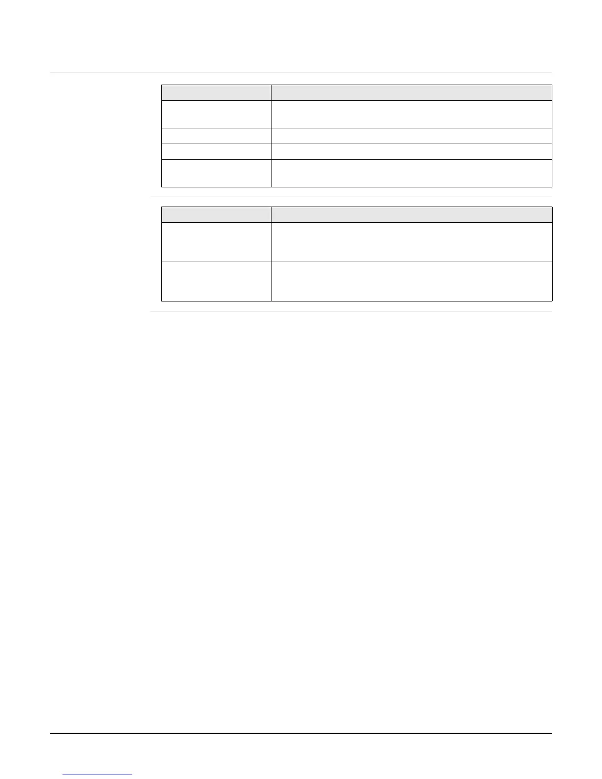
Leica GS16 Specifications

General IconGeneral
Channels555
GNSS SupportedGPS, GLONASS, Galileo, BeiDou, QZSS, SBAS
Operating Temperature-40°C to +65°C
Battery LifeUp to 10 hours
RTK Accuracy (Horizontal)8 mm + 1 ppm
RTK Accuracy (Vertical)15 mm + 1 ppm
Dust and Water ProtectionIP68
Static Accuracy (Horizontal)3 mm + 0.5 ppm
Static Accuracy (Vertical)5 mm + 0.5 ppm
Data Logging Rate20 Hz
CommunicationBluetooth

Related product manuals