 Loading...
Do you have a question about the Leica GS16 and is the answer not in the manual?
| Channels | 555 |
|---|---|
| GNSS Supported | GPS, GLONASS, Galileo, BeiDou, QZSS, SBAS |
| Operating Temperature | -40°C to +65°C |
| Battery Life | Up to 10 hours |
| RTK Accuracy (Horizontal) | 8 mm + 1 ppm |
| RTK Accuracy (Vertical) | 15 mm + 1 ppm |
| Dust and Water Protection | IP68 |
| Static Accuracy (Horizontal) | 3 mm + 0.5 ppm |
| Static Accuracy (Vertical) | 5 mm + 0.5 ppm |
| Data Logging Rate | 20 Hz |
| Communication | Bluetooth |
Lists available documentation and describes the myWorld@Leica Geosystems platform services.
Explains safety directions, hazard levels, operational risks, and essential precautions for safe use.
Covers EMC, radio device precautions, and compliance with FCC/Canadian regulations.
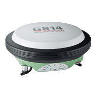
Lists system components, explains software/power concepts, and covers data storage methods.
Details instrument buttons, functions, and button combinations for operation.
General setup and step-by-step instructions for base and rover configurations.
Details connecting to PC, driver installation, and accessing the instrument's web server.
Covers battery use, replacement, memory card insertion, and RTK SIM card management.
Explains LED indicators and provides tips for achieving accurate GNSS survey results.
Guidelines for safely transporting, storing, and cleaning the instrument and its accessories.
Covers tracking characteristics, accuracy, dimensions, power, operating times, and environmental specs.
Outlines the terms and conditions governing the use of the product's software.
Identifies instrument ports and details pin assignments for USB/serial communication.