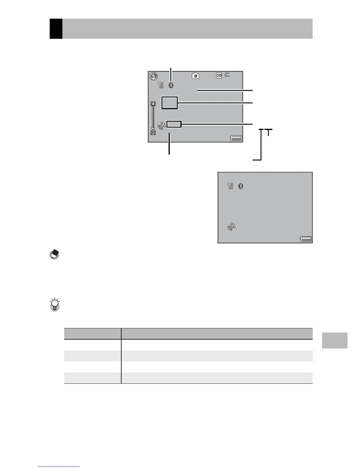
EasyManuals Logo

Ricoh G700SE User Manual

Ricoh G700SE
197 pages
To Next Page IconTo Next Page
To Previous Page IconTo Previous Page
Page #140 background imageLoading...
Page #140 background image
139
GPS
13
The GPS Data Display
During shooting, GPS data
are displayed as shown
at right.
4:
3 F
3 F4:3 F
4:3 F
9999
99999999
9999
11
1
359.2˚//NNW/mag
359.2˚//NNW/mag359.2˚//NNW/mag
359.2˚//NNW/mag
E:
139˚
139˚E:139˚
E:139˚
N:
035˚
035˚N:035˚
N:035˚
X3
(
4
)
X3
(
4
)
X3
(
4
)
2d
2d2d
2d
Bluetooth® icon
(Bluetooth®-equipped GPS units only)
Heading (GP-1)
Accuracy
×3(4)
Satellites visible
at current
location
Number of
satellites used
Latitude/
longitude
To view more data, press DISP.
11
1
359.2˚//NNW/mag
359.2˚//NNW/mag359.2˚//NNW/mag
359.2˚//NNW/mag
E:
139
139˚
31
31
39.565”
39.565E:139˚ 31 39.565
E:139˚31’39.565”
N:
035
035˚
34
34
50.428”
50.428N:035˚ 34 50.428
N:035˚34’50.428”
X3
(
4
)
X3
(
4
)
X3
(
4
)
2d
2d2d
2d
Note -------------------------------------------------------------------------------------
The format for the compass heading and for latitude and longitude can be
chosen using the [Compass Heading] (GP.100) and [GPS Disp Mode] (GP.99)
options in the expanded settings menu (GP.98).
Accuracy -------------------------------------------------------------------------------
The accuracy of the GPS data is displayed as shown below:
Display Contents
no fix The GPS unit cannot receive data.
2d The NMEA-0183 format GSA positioning mode is 2d.
3d The NMEA-0183 format GSA positioning mode is 3d.
Diff The NMEA-0183 format GGA quality is DGPS.

Table of Contents

Other manuals for Ricoh G700SE

Questions and Answers:

Question and Answer IconNeed help?

Do you have a question about the Ricoh G700SE and is the answer not in the manual?

Ricoh G700SE Specifications

General IconGeneral
BrandRicoh
ModelG700SE
CategoryDigital Camera
LanguageEnglish

Related product manuals