Garmin G1000 Pilot’s Guide for the Piper PA-32 Saratoga
190-02692-00 Rev. A230
FLIGHT MANAGEMENT
SYSTEM
OVERVIEW
FLIGHT
INSTRUMENTS
EIS
AUDIO PANEL
& CNS
FLIGHT
MANAGEMENT
HAZARD
AVOIDANCE
AFCS
ADDITIONAL
FEATURES
APPENDICESINDEX
The vertical navigation profile can be modified by directly entering a vertical speed target (VS TGT) and/or flight
path angle (FPA) in the CURRENT VNV PROFILE box.
Modifying the VS TGT and FPA:
1) Press the FPL Key on the MFD to display the FPL – ACTIVE FLIGHT PLAN Page.
2) Press the VNV PROF Softkey; or press the MENU Key, highlight ‘Select VNV Profile Window’, and press the ENT
Key. The cursor is now located in the CURRENT VNV PROFILE Box.
3) Turn the FMS Knobs as needed to edit the values.
4) PUSH the FMS Knob to remove the flashing cursor.
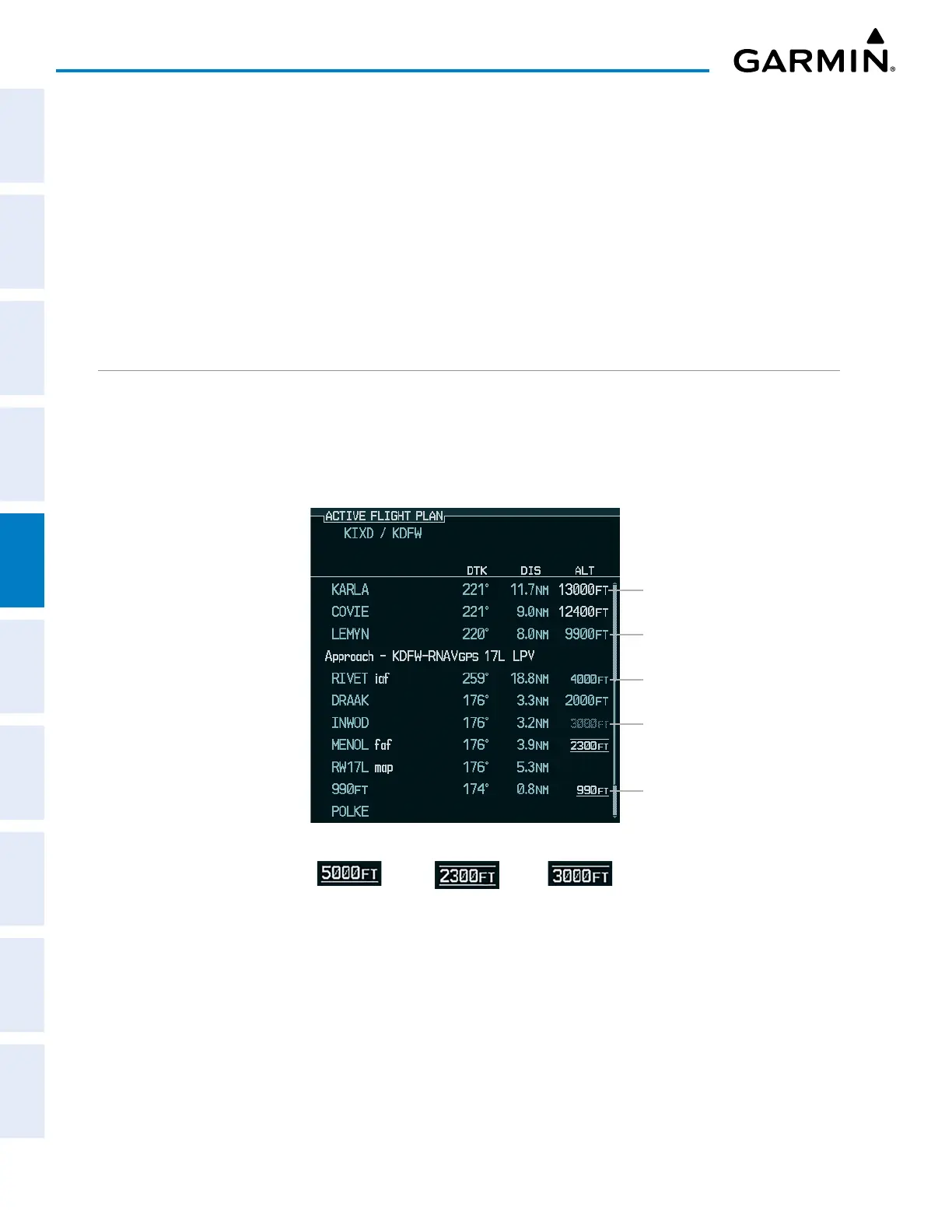
ALTITUDE CONSTRAINTS
The system can use altitude constraints associated with lateral waypoints to give guidance for vertical
navigation. These altitudes are, depending on the specific instance, manually entered or retrieved from the
published altitudes in the navigation database. The navigation database only contains altitudes for procedures
that call for “Cross at” altitudes. If the procedure states “Expect to cross at,” then the altitude is not in the
database. In this case the altitude may be entered manually.
Figure 5-73 Waypoint Altitude Constraints
Cross AT
or ABOVE
5,000 ft
Cross AT
or BELOW
3,000 ft
Cross AT
2,300 ft
Altitude Constraint Examples
Large Cyan Text
Small White Text with Altitude
Restriction Bar
Large White Text
Small Cyan Subdued Text
Small Cyan Text
Altitude constraints are displayed and entered in feet mean sea level (MSL) values to the nearest hundred. An
altitude constraint in feet above ground level (AGL) format is supported for airports. When a database altitude
restriction is displayed, the system allows entry of a different altitude when creating a waypoint, effectively
overriding the database restriction (only before the FAF). When a database altitude restriction of type “AT or
ABOVE” or “AT or BELOW” is activated, the system uses the “AT” portion of the restriction to define the vertical
profile.
 Loading...