190-02692-00 Rev. A
Garmin G100 Pilot’s Guide for the Piper PA-32 Saratoga 53
FLIGHT INSTRUMENTS
SYSTEM
OVERVIEW
FLIGHT
INSTRUMENTS
EIS
AUDIO PANEL
& CNS
FLIGHT
MANAGEMENT
HAZARD
AVOIDANCE
AFCS
ADDITIONAL
FEATURES
APPENDICES INDEX
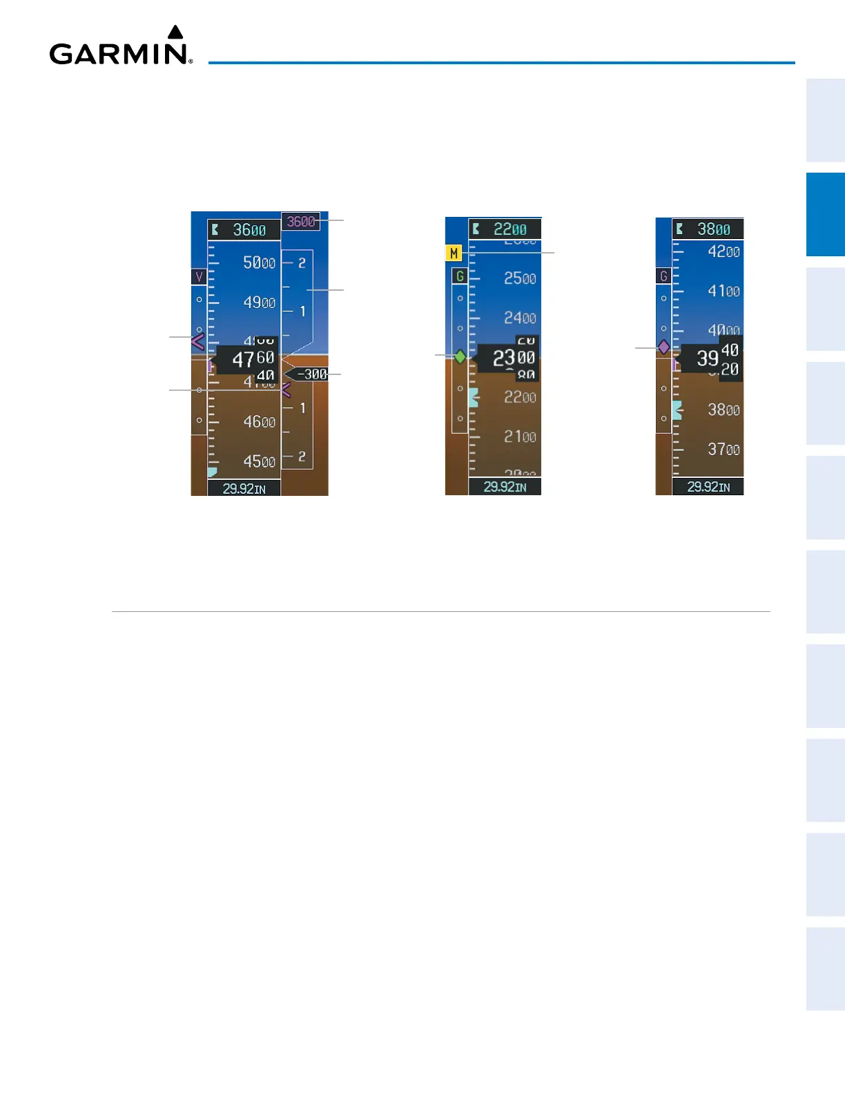
The glidepath is analogous to the glideslope for GPS approach service levels supporting SBAS vertical
guidance (LNAV+V, L/VNAV, LPV, LP+V). When a GPS approach with one of these service levels is loaded into
the flight plan and GPS is the selected navigation source, the Glidepath Indicator appears as a magenta diamond
during the approach. Full-scale deflection (two dots), is angular with upper and lower limits. If the approach
downgrades past the final approach fix (FAF), ‘NO GP’ is displayed in place of the diamond.
Glipepath
Indicator
Glidepath Indicator
Glideslope
Indicator
Marker Beacon
Annunciation
Vertical
Speed
Indicator
Required
Vertical
Speed
Vertical
Speed
Pointer
VNV Target
Altitude
Vertical
Deviation
Indicator
Vertical Speed and Deviation
Indicators (VSI and VDI)
Glideslope Indicator
Figure 2-10 Vertical Speed and Vertical Deviation Indications
HORIZONTAL SITUATION INDICATOR (HSI)
The Horizontal Situation Indicator (HSI) displays a rotating compass card in a heading-up orientation. Letters
indicate the cardinal points with numeric labels every 30˚. Major tick marks are at 10˚ intervals and minor
tick marks are at 5˚degree intervals. A digital reading of the current heading appears on top of the HSI, and
the current track is represented on the HSI by a magenta diamond. The HSI also presents turn rate, course
deviation, bearing, and navigation source information. The HSI is available in two formats: a 360˚ compass
rose and a 140˚ arc.
Changing the HSI display format:
1) Press the
PFD
Softkey
2) Press the HSI FRMT Softkey.
3) Press the
360 HSI
or
ARC HSI
Softkey.
4) Press the BACK Softkey twice to return to the top-level softkeys.
The 360˚ HSI contains a Course Deviation Indicator (CDI), with a Course Pointer, To/From Indicator, sliding
Deviation Bar and scale. The Course Pointer is a single line arrow (GPS, VOR1, and LOC1) or a double line
arrow (VOR2 and LOC2) which points in the direction of the set course. The To/From arrow rotates with the
Course Pointer and is displayed when the active NAVAID is received.
 Loading...