Garmin G1000 Pilot’s Guide for the Piper PA-32 Saratoga
190-02692-00 Rev. A
366
HAZARD AVOIDANCE
SYSTEM
OVERVIEW
FLIGHT
INSTRUMENTS
EIS
AUDIO PANEL
& CNS
FLIGHT
MANAGEMENT
HAZARD
AVOIDANCE
AFCS
ADDITIONAL
FEATURES
APPENDICESINDEX
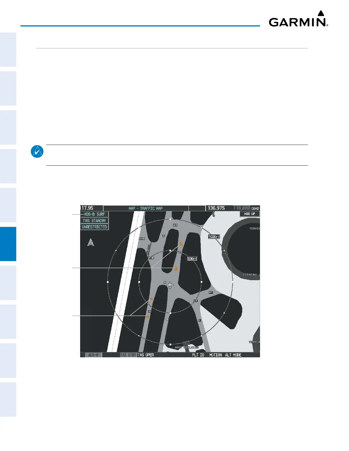
AIRBORNE AND SURFACE APPLICATIONS
The SKY497 can help the pilot visually acquire traffic both in the air and on-the-ground. There are two ADS-B
applications or modes: Airborne Situational Awareness (AIRB) and Surface Situational Awareness (SURF). The
system automatically selects the appropriate application based on conditions.
The AIRB application is on when the aircraft is more than five NM and 1,500 feet above the nearest airport.
When the AIRB application is active, the system only displays traffic which is airborne.
The SURF application is on when the aircraft is within five NM and less than 1,500 feet above field elevation.
When the SURF applications is on, the system displays airborne and on the ground traffic. At a MAP - TRAFFIC
MAP Page range of two nm or less, the airport environment (including taxiways and runways) appears in
addition to traffic. The airport displays are derived from the SafeTaxi database. Refer to the Additional Features
section for more information about SafeTaxi displays.
NOTE: Do not rely on the solely on the traffic display to determine the runway alignment of traffic, especially
when runways are in close proximity to each other.
Due to the varying precision of the data received via ADS-B, ADS-R, and TIS-B, all traffic information may not
be depicted on the traffic display. Because higher data precision is required for display in the SURF environment,
some traffic eligible for AIRB will not be displayed while SURF is on. Individual eligibility for AIRB and SURF
is depicted on the AUX-ADS-B STATUS Page, discussed later in this section.
SURF Application
On
Aircraft traffic is on
the ground
Ground Vehicles
Figure 6-90 MAP - TRAFFIC MAP Page with SURF Mode On
 Loading...