Garmin G1000 Pilot’s Guide for the Piper PA-32 Saratoga
190-02692-00 Rev. A12
SYSTEM OVERVIEW
SYSTEM
OVERVIEW
FLIGHT
INSTRUMENTS
EIS
AUDIO PANEL
& CNS
FLIGHT
MANAGEMENT
HAZARD
AVOIDANCE
AFCS
ADDITIONAL
FEATURES
APPENDICESINDEX
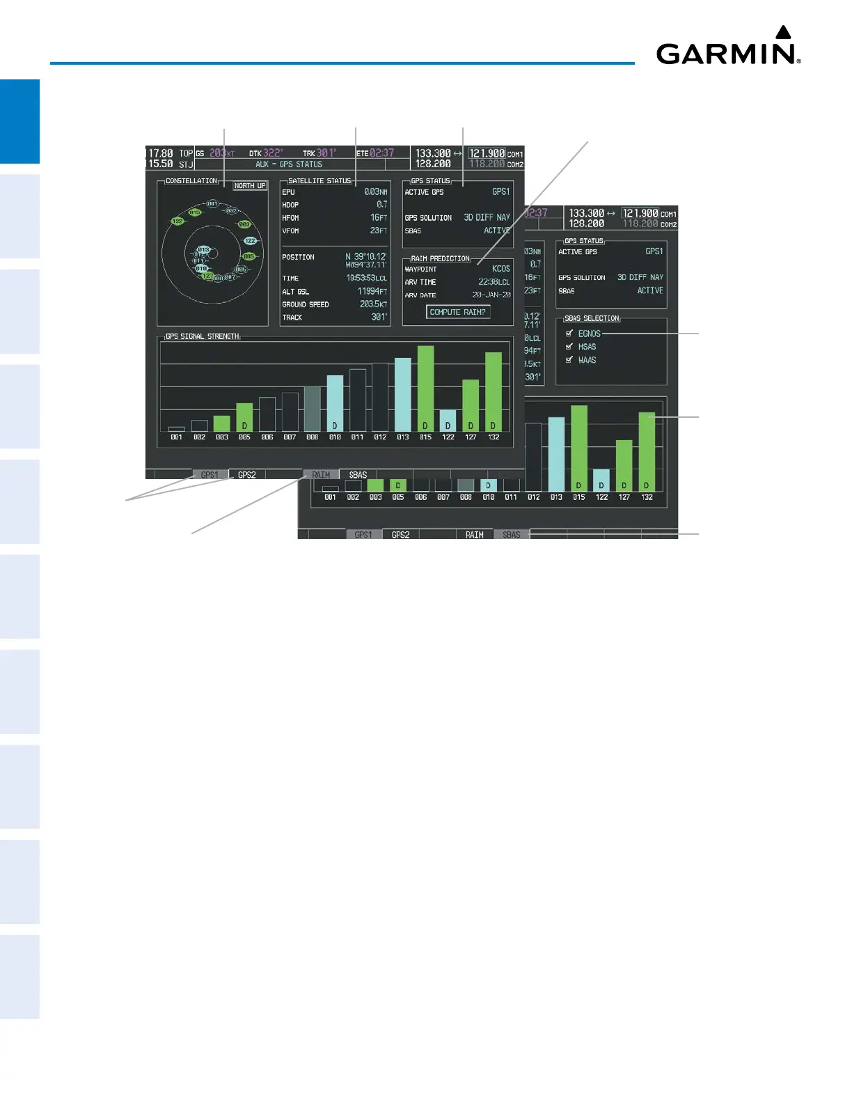
Figure 1-9 AUX – GPS STATUS Page (RAIM or SBAS Softkey Selected)
Satellite
Signal
Strength
Bars
Satellite Constellation
Diagram
Satellite Signal
Information Status
RAIM
Availability
Prediction
GPS Receiver
Status
SBAS
Selected
RAIM Softkey
Selected
SBAS
Softkey
Selected
GPS Selection
Softkeys
The AUX – GPS STATUS Page provides the following information:
SATELLITE CONSTELLATION DIAGRAM
Satellites currently in view are shown at their respective positions on a sky view diagram. The sky view is
always in a north-up orientation, with the outer circle representing the horizon, the inner circle representing
45° above the horizon, and the center point showing the position directly overhead.
Each satellite is represented by an oval containing the Pseudorandom Noise (PRN) number (i.e., satellite
identification number). Satellites whose signals are currently being used are represented by solid ovals.
SATELLITE SIGNAL INFORMATION STATUS
The accuracy of the aircraft’s GPS fix is calculated using Estimated Position Uncertainty (EPU), Dilution
of Precision (DOP), and horizontal and vertical figures of merit (HFOM and VFOM). EPU is the radius of a
circle centered on an estimated horizontal position in which actual position has 95% probability of laying.
EPU is a statistical error indication and not an actual error measurement.
DOP measures satellite geometry quality (i.e., number of satellites received and where they are relative to
each other) on a range from 0.0 to 9.9, with lower numbers denoting better accuracy. HFOM and VFOM,
measures of horizontal and vertical position uncertainty, are the current 95% confidence horizontal and
vertical accuracy values reported by the GPS receiver.
The current calculated GPS position, time, altitude, ground speed, and track for the aircraft are displayed
below the satellite signal accuracy measurements.
 Loading...