1-3
Autonomous Navigation
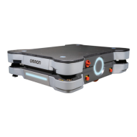
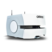
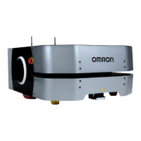
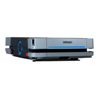
The AMR combines hardware and mobile-robotics software to provide an adaptive, mobile platform to
transport a payload. It is equipped with a Natural Feature Navigation system which enables the AMR
to navigate and perform its basic functions independently and without the need for facility modification.
After it scans physical features in its environment, the AMR navigates safely and autonomously to any
accessible destination. It can move continuously and without human intervention, autonomously re-
charging itself as necessary.
Navigation paths are updated many times per second to maintain a smooth trajectory and to avoid ob-
stacles detected by the on-board sensors. An AMR reacts to obstacles in its path by slowing and if
necessary, stopping safely. It then either plans a new path around the obstacle or, if the obstacle has
moved, resumes its original path. If no such path is available, the AMR fails the current job. Path plan-
ning parameters, together with constraints specified in the AMR's workspace map, define the path that
the AMR will plan and follow through its environment. Use the MobilePlanner software to modify the
AMR's path planning parameters as required for your environment.
The AMR can operate independently, without a wireless connection in areas where no other AMRs are
present. In this mode, the AMR uses a map that is stored internally for all navigation and pre-config-
ured tasks. When an AMR operates in an area with other AMRs, wireless connectivity to a Fleet Man-
ager is required. Refer to 1-6-1 Fleet Manager on page 1-26 for more information.
Navigational parameters are stored on the AMR Controller and can be viewed and modified using the
MobilePlanner software.
CAUTION
Although the AMR's software provides the option of using the map features to keep
the AMR within its designated workspace, poor or improper localization may result in
incorrect path planning. To ensure safety, you must always install physical barriers
where there is a risk of property damage or personal hazard.
The MobilePlanner software configures the many high-level operating characteristics of the AMR and
typically communicates with the AMR over a wireless network. A direct connection through the Mainte-
nance Ethernet Port on the AMR is also possible.
The AMR uses range data from the Safety Laser Scanner as its primary means of detecting obstacles
and of maintaining an accurate understanding of its location in the environment. Additionally, it uses
data from the following sensors:
• Two Low Lasers at the opposing corners of the AMR to detect objects below the plane of the Safety
Laser Scanner.
• Encoders (one on each drive motor) provide information on the distance traveled by each drive
wheel and direction of travel.
• Gyroscopic inertial sensors to track the AMR's rotation.
Before an AMR enters a high-traffic area, you must take appropriate precautions to alert people work-
ing in those areas. The AMR provides programmable warning features such as a warning buzzer,
speech synthesis, and warning indicator lights. The User Connections area provides user ports that
enable you to add additional warning indicators to your payload structure.
If high-traffic areas include other moving vehicles such as fork-lift trucks or autonomous moving ma-
chines, consider adjusting the AMR's operating parameters to reduce the risk of a collision.You can do
this with one of the following methods.
1 Overview
1-17
AMR (Autonomous Mobile Robot) MD-series Platform User's Manual (I681)
1-3 Autonomous Navigation
1
 Loading...