EasyManua.ls Logo

Raymarine A65 User Manual

Raymarine A65
388 pages
To Next Page IconTo Next Page
To Previous Page IconTo Previous Page
Page #143 background imageLoading...
Page #143 background image
Buildingaroute
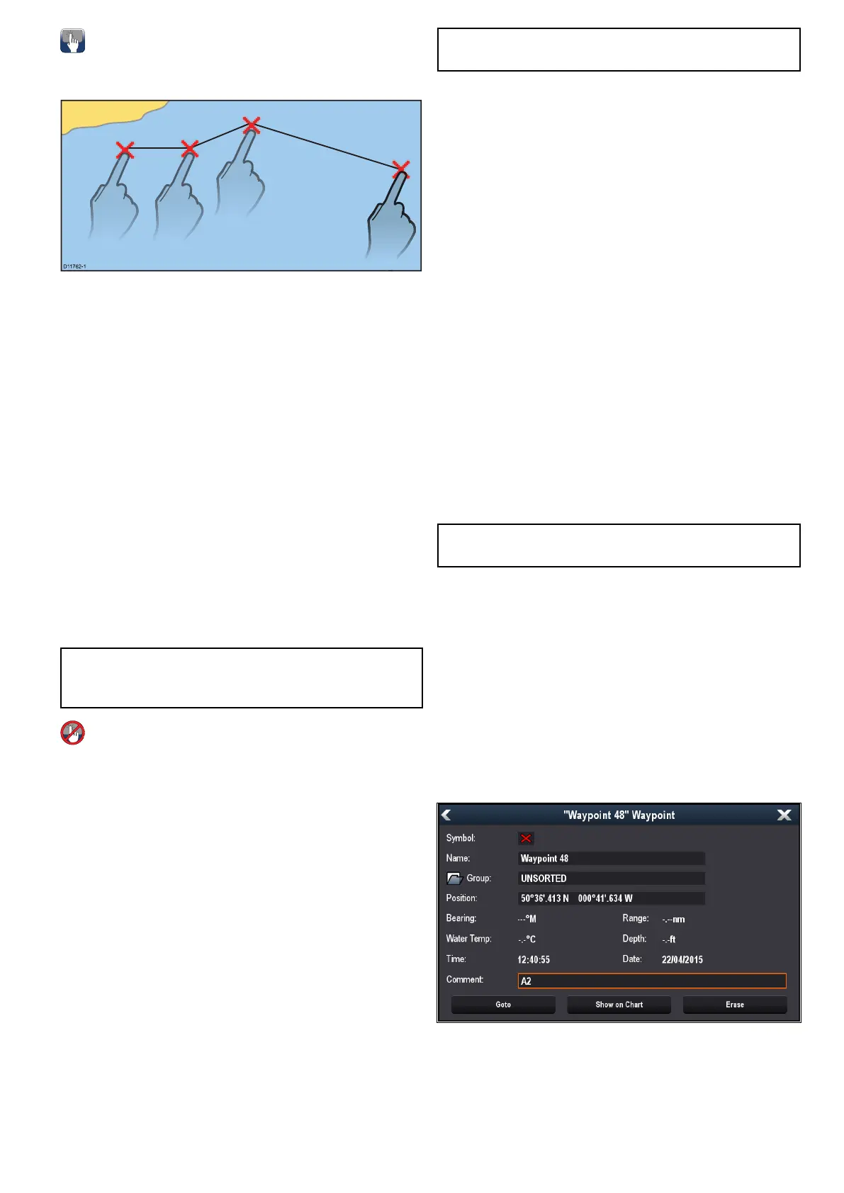
Youcanbuildarouteonatouchscreenmultifunction
displaybyfollowingthestepsbelow.
D117 62-1
Fromthechartapplication:
1.Selectandholdalocationonscreen.
Thechartcontextmenuisdisplayed.
2.SelectBuildRoute.
Thebuildroutemenuisdisplayed.
3.Selectalocationonscreentobethestarting
position.
4.Selectrelevantlocationstoplacesubsequent
waypointsinorder.
Therouteissavedanddisplayedaseach
waypointisplaced.
5.WhencompleteselectFinishBuild.
Thenishroutebuildpopupmessageis
displayed.
6.SelectFollowtoimmediatelyfollowtheroute.or
7.SelectEdittochangetheroutenameorchange
theroutecolor.or
8.SelectExittosavetherouteandreturntothe
chartapplication.
Note:Ifyouplaceawaypointatthewrong
position,selectUndoWaypointfromtheRoute
Menu.
Buildingaroute
Fromthechartapplication:
1.SelectMenu.
2.SelectNavigate.
3.SelectBuildRoute.
Thebuildroutemenuisdisplayed.
4.SelectPlaceWpt.
5.UsingtheJoystickselectalocationonscreen.
6.PresstheOkbuttontoplacetherstwaypoint
intheroute.
7.UsetheJoystickandtheOkbuttontoplace
subsequentwaypoints.
Therouteissavedanddisplayedaseach
waypointisplaced.
8.WhenyourrouteiscompleteselectFinishBuild.
Thenishroutebuildpopupmessageis
displayed.
9.SelectFollowtoimmediatelyfollowtheroute.or
10.SelectEdittochangetheroutenameorchange
theroutecolor.or
11.SelectExittosavetherouteandreturntothe
chartapplication.
Note:Ifyouplaceawaypointatthewrong
position,selectUndoWaypoint.
Buildingarouteusingthewaypointlist
Fromthechartapplication:
1.SelectMenu.
2.SelectNavigate.
3.SelectBuildRoute.
Thebuildroutemenuisdisplayed.
4.SelectUseWPTList.
Thewaypointlistisdisplayed.
5.Selecttherequiredwaypoint.
Youwillbetakenbacktothebuildroutemenu.
6.Addsubsequentwaypointstotheroute.
Therouteissavedanddisplayedaseach
waypointisplaced.
7.WhenyourrouteiscompleteselectFinishBuild.
Thenishroutebuildpopupmessageis
displayed.
8.SelectFollowtoimmediatelyfollowtheroute.or
9.SelectEdittochangetheroutenameorchange
theroutecolor.or
10.SelectExittosavetherouteandreturntothe
chartapplication.
Note:Ifyouselectthewrongwaypoint,select
UndoWaypointfromtheroutemenu.
BuildingarouteusingracemarkIDs
Youcanbuildaroutequicklybyenteringalistof
racemarkIDs.EachRacemarkIDmustbeunique
andmusthavebeenenteredintothecommentseld
oftherelevantwaypoints.
RacemarkIDsmust:
onlyusealphanumericcharacters
notincludeanyspaces
beseparatedfromanyotherinformationinthe
eldusingaspace.
FromtheChartapplicationmenu:
1.SelectMyData.
2.SelectRoutes.
3.SelectBuildusingracemarkIDs.
Aninstructionalpop-upisdisplayed,unlessyou
havepreviouslyselectedDon’tshowagain.
Waypoints,RoutesandTracks
143

Table of Contents

Other manuals for Raymarine A65

Question and Answer IconNeed help?

Do you have a question about the Raymarine A65 and is the answer not in the manual?

Raymarine A65 Specifications

General IconGeneral
GPSYes
ChartplotterYes
Radar CompatibleYes
SonarYes
Display TypeColor LCD
Chart CompatibilityNavionics

Summary

LightHouse Operation Instructions

Document and Software Changes

Chapter 1: Important Information

Safe Navigation and Route Generation Warnings

Covers safe navigation practices, route generation limitations, and traffic separation rules.

Equipment Operation Safety Warnings

Safety precautions for radar transmission, sonar operation, and touchscreen display usage.

Care and Handling of Cards and Product

Covers care for chart/memory cards, secure card reader, sun covers, and product cleaning.

Chapter 3: Getting Started

Initial Setup Procedures and Vessel Details

Guides through startup wizard, boat details (depth, beam, height), time/date, data master, and GPS setup.

Chapter 4: Managing Display Data

Saving and Restoring User Data

Instructions for saving, exporting, importing, and erasing waypoints, routes, tracks, and settings.

Chapter 5: Customizing Your Display

Chapter 7: Autopilot Control

Autopilot Control Overview and Enabling Procedures

Introduces autopilot control features and guides on enabling it for different autopilot types.

Engaging, Disengaging, and Adjusting Autopilot

Instructions on engaging, disengaging, and adjusting the autopilot's heading and modes.

Pilot Set-up, Settings, and Commissioning

Covers pilot set-up, vessel settings, drive settings, rudder alignment, and system monitoring.

Chapter 8: Alarm Management

Alarms Overview and Management Functions

Explains alarm types, color coding, acknowledging alarms, and using the Alarm Manager.

Changing Alarm Thresholds and Managing History

Details how to change alarm thresholds, enable/disable alarms, and clear alarm history.

Alarm Options and Specific Settings

Configures safety, general, switch panel, and engine alarms, including thresholds and options.

Chapter 9: Man Overboard (MOB)

Man Overboard (MOB) Functionality and Activation

Explains how to activate, cancel MOB alarms, and the waypoint (MOB) button/icon.

Chapter 10: DSC VHF Radio Integration

Chapter 11: Fuel Manager

Fuel Manager Overview, Setup, and Logging Procedures

Explains fuel manager overview, enabling/disabling, setting capacity, economy units, and fuel logging.

Chapter 12: AIS (Automatic Identification System)

AIS Overview and Prerequisites for Operation

Details AIS overview, target types, status, symbols, and system prerequisites for functionality.

Dangerous Targets and Collision Avoidance Features

Details dangerous targets, collision avoidance features, target interception, and course/speed change examples.

Chapter 13: Waypoints, Routes, and Tracks

Waypoints Overview, Placement, and Group Management

Details waypoint display, context menu, placement, groups, searching, and symbols.

Route Creation and Management Procedures

Covers route features, building routes, automatic route generation, review, editing, and troubleshooting.

Chapter 14: Chart Application

Chart Application Overview and Core Features

Details chart application features for navigation, route planning, and electronic charts.

Collision Avoidance Features Overview

Details AIS, MARPA, Target Interception, Guard Zone Alarm, and Dangerous Targets for collision avoidance.

Chapter 15: Fishfinder Application

Fishfinder Features and Sonar Module Support

Details fishfinder features, sonar modules, selecting channels/transducers, and troubleshooting crosstalk.

Fishfinder Display Modes and Sensitivity Settings

Covers display modes (Zoom, A-Scope, Bottom Lock), sensitivity settings, gain, contrast, noise filter, alarms, and frequency tuning.

Chapter 16: Radar Application

Radar Application Overview, Features, and Scanner Status

Details radar features, scanner types, sensitivity controls, gain modes, and status symbols.

Radar Range, Image Quality, and Interference Factors

Covers radar range, image quality factors (side lobes, echoes, clutter, interference), and maximum range.

Collision Avoidance and MARPA Operations

Details collision avoidance features (AIS, MARPA) and MARPA operation and risk assessment.

Chapter 17: Data Application

Engine Identification and Boat Details Setup

Covers engine data display, identification wizard, and setting boat details like engines and fuel tanks.

Chapter 18: Camera Application

Camera Application Overview and Feed Management

Details camera application overview, changing feeds, switching streams, Quad View, and camera cycling.

Recording, Playback, Photo Capture, and LED Control

Explains recording IP camera feeds, playback, taking photos, viewing images, and camera LED control.

Chapter 19: Thermal Camera Application — Pan and Tilt Cameras

Thermal Camera Overview and Image Display Features

Details thermal camera overview, image display, status icons, setup, and image adjustments.

Chapter 20: Thermal Camera Application — Fixed Mount Cameras

Fixed Mount Thermal Camera Overview and Image Display

Details fixed mount thermal camera overview, image display, status icons, setup, and image adjustments.

Chapter 21: Wi-Fi and Mobile Applications

MFD Wi-Fi and Access Point Connection

Covers enabling MFD Wi-Fi, connecting to access points/hotspots, and removing saved networks.

Chapter 22: Media Player Application

Chapter 25: Weather Application (North America only)

Chapter 26: Troubleshooting

General Troubleshooting and Power Issues

Provides general troubleshooting steps and solutions for power-up problems.

Radar and GPS Troubleshooting Guidance

Covers troubleshooting for radar issues (no data, incorrect bearing) and GPS issues (no fix).

Route Generation and Sonar Troubleshooting

Addresses issues with automatic route generation and sonar problems (scrolling, depth, interference).

Video, Wi-Fi, Bluetooth, Touchscreen, and Miscellaneous Issues

Covers troubleshooting for video, Wi-Fi, Bluetooth, touchscreen, and general erratic behavior.
Related product manuals