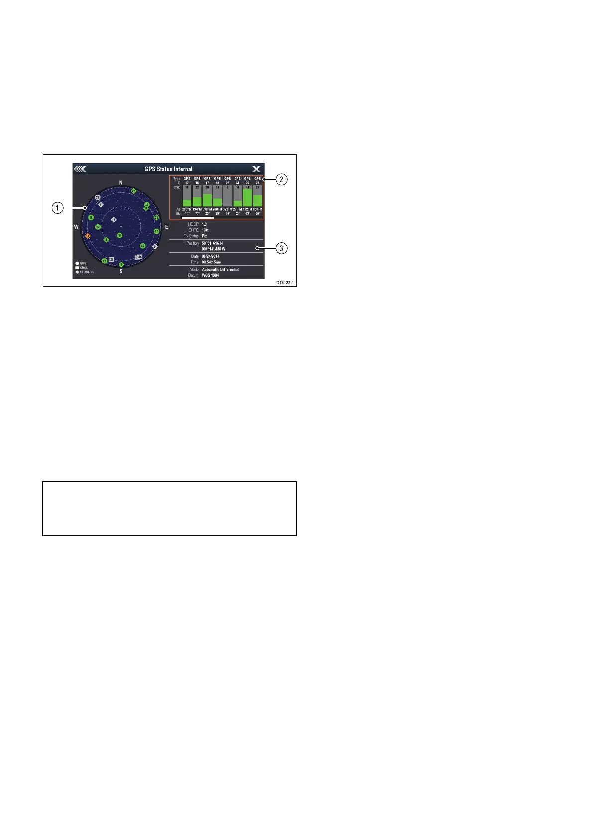
3.18GNSSStatus
TheGPSstatuspageenablesyoutoviewthestatus
oftheavailablesatellitesthatarecompatiblewith
yourreceiver.
Thesatelliteconstellationsareusedtopositionyour
vesselintheChartandWeatherapplications.You
cansetupyourreceiverandcheckitsstatusfrom
theGPSSet-upmenu:Homescreen>Set-up>
SystemSettings>GPSSet-up.Foreachsatellite,
thescreenprovidesthefollowinginformation:
1.Skyview
2.Satellitestatus
3.Positionandxinformation
Skyview
Skyviewisavisualrepresentationthatshows
thepositionofnavigationsatellitesandtheirtype.
Satellitetypesare:
•Circle—Acircleidentiesasatellitefromthe
GPSconstellation.
•*Diamond—Adiamondidentiesasatellitefrom
theGLONASSconstellation.
•Square—Asquareidentiesan(SBAS)
differentialsatellite.
Note:*GLONASSsatellitesareonlyavailable
whenconnectedtoacompatibleGNSSreceiver.
RefertotheTechnicalspecicationforyour
producttoidentifyyourreceivertype.
Satellitestatusarea
TheSatellitestatusareadisplaysthefollowing
informationabouteachsatellite:
•Type—Identieswhichconstellationthesatellite
belongsto.
•ID—Displaysthesatellitesidenticationnumber.
•CNO(Carrier-to-noiseratio)—Displaysthesignal
strengthofeachsatelliteshownintheSkyview:
–Grey=searchingforsatellite
–Green=satelliteinuse
–Orange=trackingsatellite
•AzimuthandElevation—Providestheangleof
elevationandazimuthbetweenthelocationofthe
receiverandthesatellite.
Positionandxinformation
Thefollowingpositionalandxinformationis
provided:
•HorizontalDilutionofPrecision(HDOP)
—HDOPisameasureofsatellitenavigation
accuracy,calculatedfromanumberoffactors
includingsatellitegeometry,systemerrorsin
thedatatransmissionandsystemerrorsinthe
receiver.Ahigherguresigniesagreater
positionalerror.Atypicalreceiverhasanaccuracy
ofbetween5and15m.Asanexample,assuming
areceivererrorof5m,anHDOPof2would
representanerrorofapproximately15m.Please
rememberthatevenaverylowHDOPgureis
NOguaranteethatyourreceiverisprovidingan
accurateposition.Ifindoubt,checkthedisplayed
vesselpositionintheChartapplicationagainst
youractualproximitytoaknownchartedobject.
•EstimatedHorizontalPositionError(EHPE)
—EHPEisameasureoftheestimatederrorof
apositionxinthehorizontalplane.Thevalue
displayedindicatesthatyourpositioniswithina
circleradiusofthestatedsize50%ofthetime.
•Fixstatus—indicatestheactualmodethe
receiverisreporting:
–Fix—Satellitexhasbeenacquired.
–NoFix—Nosatellitexcanbeacquired.
–DFix—Adifferentialbeaconxhasbeen
acquired.
–SDFix—Adifferentialsatellitexhasbeen
acquired.
•Position—Displaysthelatitudeandlongitude
positionofyourreceiver.
•Date/Time—Displaysthecurrentdateandtime
generatedbythepositionxinUTCformat.
•Mode—Identieswetherthereceiverisworking
indifferentialmodeornon-differentialmode.
•Datum—Thereceiver'sdatumsettingaffects
theaccuracyofthevesselpositioninformation
displayedintheChartapplication.Inorderforyour
receiverandMFDtocorrelateaccuratelywithyour
papercharts,theymustbeusingthesamedatum.
GlobalNavigationSatelliteSystems(GNSS)
AGNSSisasystemofsatellitesthatprovides
autonomousgeo-spatialpositioningthatallows
electronicdeviceswithcompatiblereceiversto
determinetheirlocation(longitude,latitudeand
altitude).
OperationalGNSS
•GPS(NAVSTAR)GlobalPositioningSystem
USownedconstellationofsatellitesthatbecame
fullyoperationalin1995.
•GLONASSacronymfor"GLObalnaya
NAavigatsionnayaSputnikovayaSistema"or
“GlobalNavigationSatelliteSystems”
Russianownedconstellationofsatellitesthat
offeredglobalcoveragein2010.
PlannedGNSS
•Galileo
Europeansatelliteconstellationininitial
deploymentphaseduetobecomeoperationalin
2020.
•COMPASS/Beidou-2
Gettingstarted
41
 Loading...