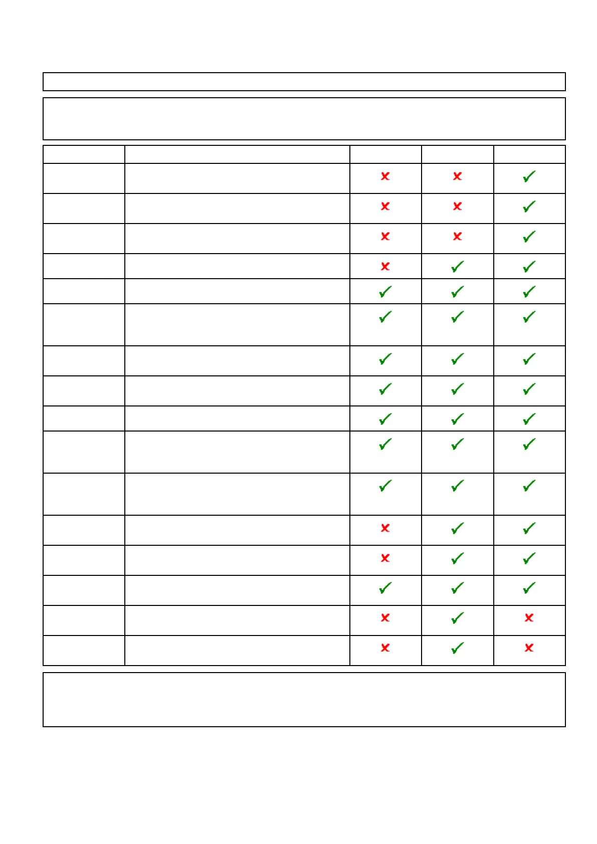
Cartographyobjects
Ifsupportedbyyoucartographytype,cartographicobjectscanbeindividuallyswitchedonandoff.
TheObjectsmenuisaccessedfrom:Menu>Presentation>Objects.
Note:TheObjectsmenuisonlyavailablewhenthecartographyinusesupportsthesefeatures.
Note:Thetablebelowidentiestheobjectssupportedbyeachcartographyvendor,howevertheobject
maynotbesupportedbyalllevelsofcartographysuppliedbythatvendor.Pleasecheckwithyour
cartographyvendorforsupportedfeatures.
ObjectDescriptionLightHouseNavionics
®
Jeppesen
®
*SportsFishingDetermineswhetherJeppesen’sSportsFishingValue
AddedData(VAD)isdisplayed.
*Protected
Areas
DetermineswhetherJeppesen’sMarineProtected
AreasValueAddedData(VAD)isdisplayed.
*FishingAOIDetermineswhetherJeppesen’sFishingAreasOf
Interest(AOI)ValueAddedData(VAD)isdisplayed.
ShowRocks
Determinesthedepthatwhichrocksaredisplayed.
Nav.MarksDetermineswhethernavigationmarksaredisplayed.
Nav.Mark
Symbols
Determineswhichsetofnavigationmarksymbols
areused—International,orUS.(Thesesymbols
correspondtopapercharts).
LightSectorsDetermineswhetherthesectoroflightcastbyaxed
beaconisdisplayed.
Routing
Systems
Determineswhetherroutingdataisdisplayedornot.
CautionAreas
Determineswhethercautiondataisdisplayed.
MarineFeaturesDetermineswhetherthewater-basedcartographic
featuressuchascables,tideandcurrentstationsand
portinformationetc.isdisplayed.
LandFeatures
Determineswhetherland-basedcartographicfeatures
suchasbuildings,towers,mastsandcoastguard
stationsetc.aredisplayed.
Business
Services
Determineswhethersymbolsindicatingthelocationof
abusinesswillbeshown.
Panoramic
Photos
Determineswhetherpanoramicphotosareavailable
forlandmarkssuchasportsandmarinas.
RoadsDetermineswhethermajorcoastalroadsaredisplayed
onthechart:
Additional
Wrecks
Determineswhetherextendedinformationfornew
wrecksisdisplayed.
ColoredSeabed
Areas
Providesgreaterdenitionoftheseabed.Thisapplies
onlytolimitedareaswheretheextradetailisavailable.
Note:*VADobjects:
•areavailableatanadditionalcostfromJeppesen
®
.
•maynotbeavailableinallareas.
Chartapplication
183
 Loading...