13.1AISoverview
TheAISfeatureenablesyoutoreceiveinformationbroadcastby
othervessels,andtoaddthesevesselsastargetsinthechart
andradarapplications.
WithanoptionalAISunitconnectedtoyoursystemyoucan:
•DisplaytargetsforanyotherAIS-equippedvessels.
•Displayvoyageinformationbeingbroadcastbythesetargets,
suchastheirposition,course,speedandrate-of-turn.
•Displaybasicordetailedinformationforeachtargetvessel,
includingsafety-criticaltargetdata.
•Setupasafezonearoundyourvessel.
•ViewAISalarmandsafety-relatedmessages.
•AddAIS-equippedfriendsandregularcontactstoa“Buddy
List”
AISinformationisdisplayedintheformofanoverlayinthechart
andradarapplications.Additionaldataisdisplayedinadialog
box,forexample:
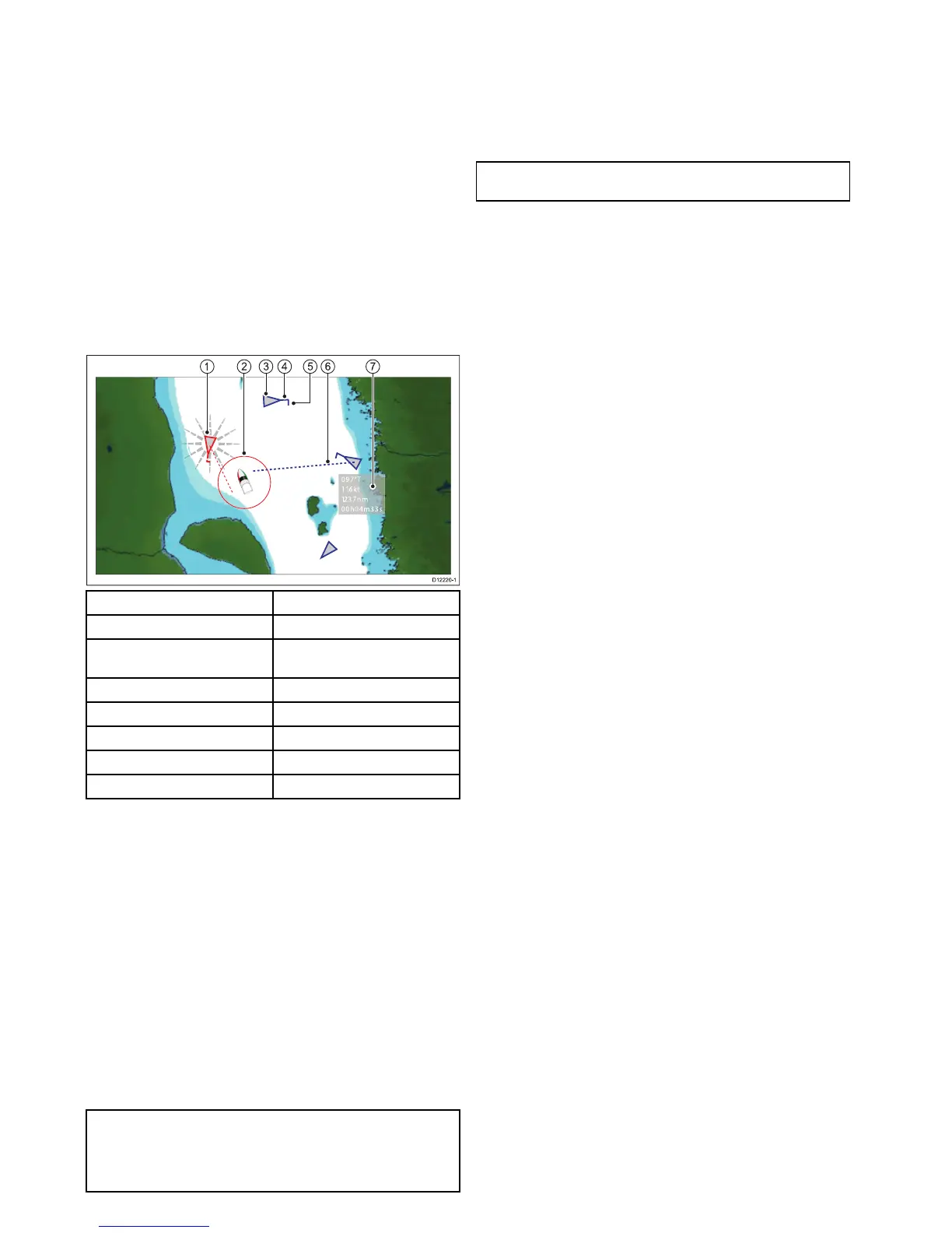
ItemDescription
1
Dangeroustarget(ashes).
2
Safezone(denedbydistanceand
/ortime).
3
AIStargetvessel.
4Heading.
5
Directionofturn.
6
COG/SOGvector.
7
Safetycriticaldata.
AIS-equippedvesselsinthesurroundingareaaredisplayed
inthechartorradarapplicationastriangulartargets.Upto
100targetsaredisplayed.Asthevessel’sstatuschanges,the
symbolforthetargetchangesaccordingly.
Vectorscanbedisplayedforeachtarget.Thesevectorsindicate
thevesselsdirectionoftravelandthedistanceitwilltravel
overaspeciedperiodoftime(COG/SOGvector).T argets
displayedwiththeirvectorsarereferredtoas‘activetargets’and
arescaledaccordingtothesizeofthevessel.Thelargerthe
vessel,thelargerthetarget.Youcaneitherdisplayalltargetsor
justdangeroustargets.
HowAISWorks
AISusesdigitalradiosignalstobroadcast‘real-time’information
betweenvesselsandshore-basedstationsviadedicatedVHF
radiofrequencies.Thisinformationisusedtoidentifyandtrack
vesselsinthesurroundingareaandtoprovidefast,automatic
andaccuratecollisionavoidancedata.TheAISfeatures
complementtheradarapplication,asAIScanoperateinradar
blindspotsandcandetectsmallervesselsequippedwithAIS.
Note:Itmaynotbemandatoryforvesselstobettedwith
operationalAISequipment.Therefore,youshouldnotassume
thatyourmultifunctiondisplaywillshowALLvesselsinyour
area.Dueprudenceandjudgementshouldbeexercised.AIS
shouldbeusedtocomplementradar,NOTsubstituteit.
AISSimulatorMode
Raymarinerecommendsthatyouusethesimulatorfunctionto
familiarizeyourselfwiththeAISfeatures.Whenthesimulator
functionisenabled(homescreen>Set-up>SystemSettings
>Simulator),itdisplays20AIStargetswithina25nmrange.
ThesetargetsaredisplayedusingtheappropriateAIStarget's
statussymbol,andmovearoundthescreenasiftheywerereal
targets.
Note:IncomingsafetymessagesareNOTdisplayedwhile
thesimulatorisenabled.
118NewaSeries/NewcSeries/NeweSeries
 Loading...