8.
1Chartappoverview
TheChartappdisplaysarepresentationofyourvesselinrelationtolandmassesandothercharted
objects,whichenablesyoutoplanandnavigatetoyourdesireddestination.TheChartapprequires
aGNSSpositionfixinordertodisplayyourvesselatthecorrectlocationonaworldmap.
ForeachinstanceoftheChartappyoucanselectwhichelectroniccartographythatyouwanttouse,
theselectionwillpersistoverapowercycle.
TheChartappcanbedisplayedinbothFullscreenandsplitscreenapppages.Apppagesmay
consistofupto4instancesoftheChartapp.
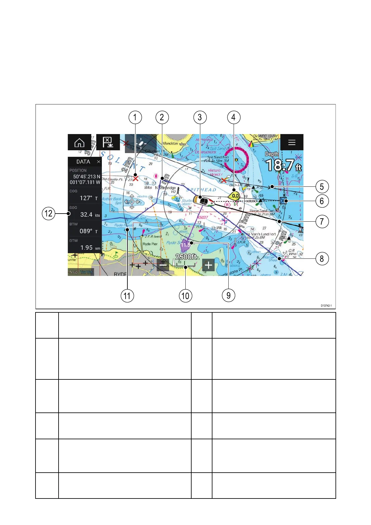
1
W aypoint
Usewaypointstomarkspecificlocation
orpointsofinterest.
2
Track
Y oucanrecordthepassageyour
vesseltakesusingTracks.
3
V esselicon
Representsyourvessel,onlydisplayed
whenGNSSpositionfixisavailable
(iconwillbeablackdotifnoHeadingis
available).
4
Windindicator
Providesindicationofwinddirection
andspeed(Windtransducerrequired).
5R oute
Y oucanplanyourrouteinadvanceby
creatingaRouteusingWaypointstomark
eachrouteleg.
6
Destinationwaypoint
Duringagoto,thisisthecurrent
destinationwaypoint.
7
Headingline
IfHeadingdataisavailablethenaHeading
vectorforyourvesselcanbedisplayed.
8
COGline
IfCOGdataisavailablethenyoucan
displayaCOGvectorforyourvessel.
9
Tideindicator
ProvidesSetanddriftindicators.R
equires
thefollowingdata;COG,Heading,SOG,
andSTW(SpeedThroughWater)..
10Chartrange
Identifiesthescaleforthechartrange
displayed.
11
R angerings
Providesadistanceindicationaroundyour
vesselatsetintervals.
12
Sidebar
TheSidebarcontainssystemdatathat
canbeviewedinallapps.
74
 Loading...
