8.4Chartsettingsmenu
ThetablebelowlistssettingsapplicabletotheChartappandtheirlocationwithintheapp
’s
Settings
menu.A
vailablesettingsaredependentonthecartographyinuse.Ifasettingisnotdisplayedthen
thefeatureisnotcompatiblewithyourcartography.Ifafeatureisgrayedoutthenitrequiresa
subscriptiontoactivatethefeature.
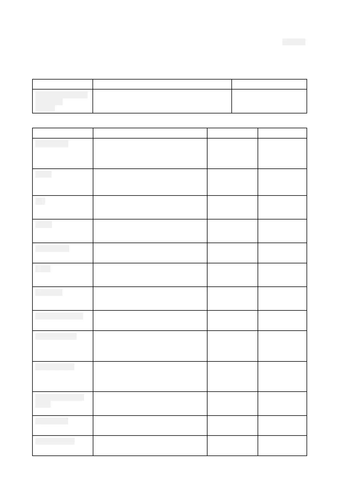
Cartography
SettingsDescriptionOptions
LightHouseCharts
Navionics
C-MAP
Allowsyoutoselectthecartographythatyou
wanttouseinthecurrentChartapp .
•Listofavailable
cartography
L ayerstab
SettingsDescriptionOptionsV endor
Chartdetail
Allowsyoutoselectthelevelofdetail
displayedonscreenforvectorbased
cartography .
•Low
•Medium
•High
•All(Vector)
Aerial
Enablesanddisablesdisplayofa
photographicaerialoverlay .
•On
•Off
•Navionics
•C-MAP
(Vector)
AISEnablesanddisablesdisplayofAIS
targetsintheChartapp .
RequiresAIShardware.
•On
•Off
•All
R adar
Enablesanddisablesdisplayofyour
Radarscanner’simageintheChartapp.
RequiresRadarscannerhardware.
•On
•Off
•All
R angerings
EnablesanddisablesdisplayofRadar
likerangeringsintheChartapp.
•On
•Off
•All
Tides
EnablesanddisablesdisplayofTide
andCurrentgraphicsatTideand
CurrentstationsintheChartapp .
•On
•Off
•Navionics
Easy View
Enablesanddisablesmagnification
ofusefuliconsandtext,makingthem
easiertoread.
•On
•Off
•Navionics
Communityedits
Enablesanddisablesdisplayofcrowd
sourceddata.
•On
•Off
•Navionics
Highresbathy
EnablesanddisablesdisplayofHigh
R esolutionBathymetrychartswhich
providesimprovedbottomdetail,
contoursandstructure.
•On
•Off
•C-MAP
Sportsfishing
Allowsyoutodisplayeasy-to-use
informationpagesaboutfishing
locationsincludingfishtype
,size,depth
andreefandbottomcomposition.
•On
•Off
•C-MAP
Marineprotected
areas
Allowsclearidentificationofareas
wherecommercialandrecreational
fishingisprohibitedorrestricted.
•On
•Off
•C-MAP
FishingA OI
EnablesanddisablesdisplayofFishing
AOIs(AreasOfInterest).
•On
•Off
•C-MAP
ActiveCaptain
Enablesanddisablesdisplayofcrowd
sourceddata.
•On
•Off
•C-MAP
Chartapp
87
 Loading...
