1
Waterlineoffset
2
Transducer/Zerooffset
3
Keeloffset
Ifanoffsetisnotapplied,displayeddepthreadingsrepresentthe
distancefromthetransducertotheseabed.
Settingthedepthoffset
FromtheTools&Settingpage:
1.SelectSystemSettings.
2.SelectSonarSet-up.
3.SelectDepthOffset.
Thedepthoffsetnumericadjustcontrolisdisplayed.
4.Adjusttheoffsettotherequiredvalue.
5.SelectOktoconrmthenewvalueandclosethenumeric
adjustcontrol.
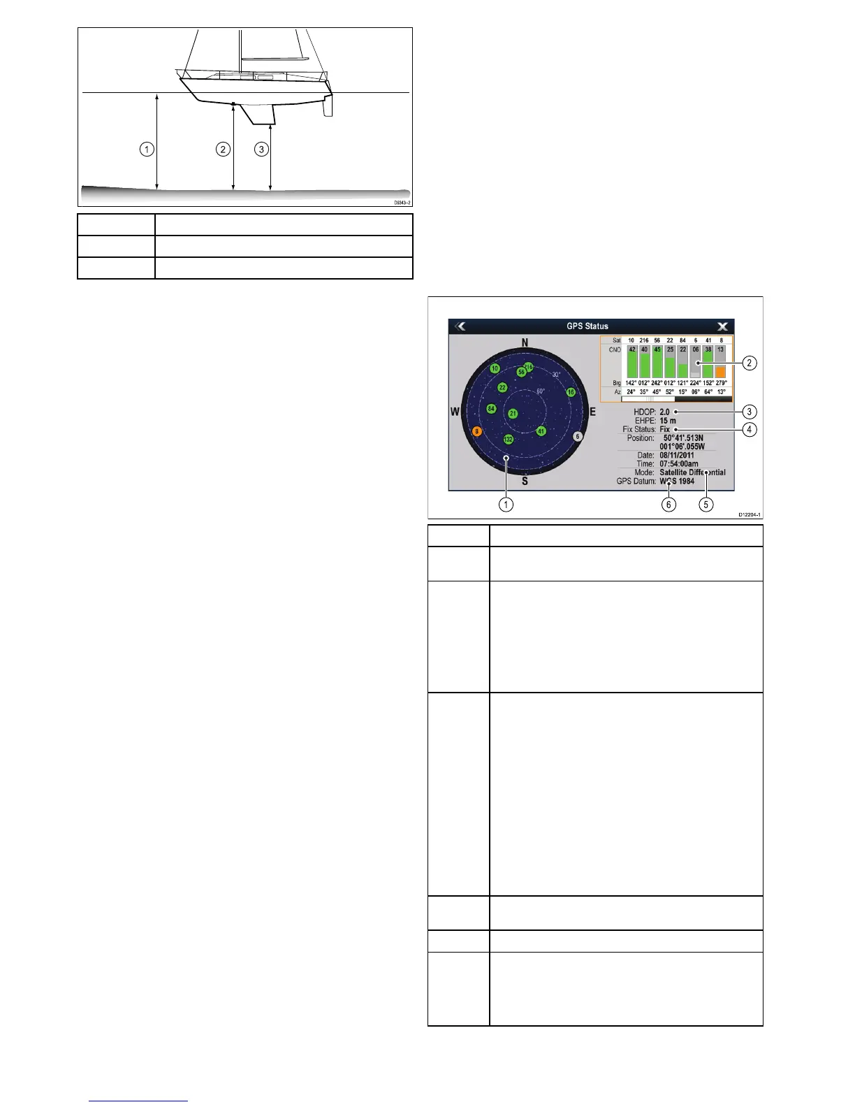
6.4GPSCheck
GPSsetup
TheGPSsetupoptionsenableyoutocongureaGPSreceiver.
TheGlobalPositioningSystem(GPS)isusedtopositionyour
vesselonthechart.YoucansetupyourGPSreceiverand
checkitsstatusfromtheGPSStatusoptionintheSystem
Settingsmenu.Foreachtrackedsatellite,thescreenprovides
thefollowinginformation:
•Satellitenumber.
•Signalstrengthbar.
•Status.
•Azimuthangle.
•Elevationangle.
•Asky-viewtoshowthepositionoftrackedsatellites.
ItemDescription
1
Skyview—avisualrepresentationofthepositionoftracked
satellites.
2
Satellitestatus—displaysthesignalstrengthandstatusof
eachsatelliteidentiedintheskyviewdiagramontheleftof
thescreen.Thecoloredbarshavethefollowingmeanings:
•Grey=searchingforsatellite.
•Green=satelliteinuse.
•Orange=trackingsatellite.
3
HorizontalDilutionofPosition(HDOP)—ameasureof
GPSaccuracy,calculatedfromanumberoffactorsincluding
satellitegeometry,systemerrorsinthedatatransmissionand
systemerrorsintheGPSreceiver.Ahigherguresignies
agreaterpositionalerror.AtypicalGPSreceiverhasan
accuracyofbetween5and15m.Asanexample,assuming
aGPSreceivererrorof5m,anHDOPof2wouldrepresent
anerrorofapproximately15m.Pleaserememberthateven
averylowHDOPgureisNOguaranteethatyourGPS
receiverisprovidinganaccurateposition.Ifindoubt,check
thedisplayedvesselpositioninthechartapplicationagainst
youractualproximitytoaknownchartedobject.
EstimatedHorizontalPositionError(EHPE)—ameasure
ofGPSaccuracy,thisindicatesthatyourpositioniswithina
circleradiusofthestatedsize67%ofthetime.
4
Fixstatus—indicatestheactualmodetheGPSreceiveris
reporting(NoFix,Fix,DFixorSDFix).
5
Mode—themodecurrentlyselectedbytheGPSreceiver.
6
Datum—TheGPSreceiver'sdatumsettingaffectsthe
accuracyofthevesselpositioninformationdisplayedin
thechartapplication.InorderforyourGPSreceiverand
multifunctiondisplaytocorrelateaccuratelywithyourpaper
charts,theymustbeusingthesamedatum.
TheaccuracyoftheGPSreceiverdependsontheparameters
detailedabove,especiallytheazimuthandelevationangles
whichareusedintriangulationtocalculateyourposition.
38
Dragony/Dragony7
 Loading...