13.1Waypointsoverview
Waypointsarepositionmarkersusedforthe
purposesofnavigation.Yourdisplaycancreate
waypoints,whichcanthenbeselectedforactive
navigation.
Therearearangeoffeaturesforplacing,navigating
andmanagingwaypoints,thesecanbeaccessed
fromtheWaypointsmenuandWaypointcontext
menu.Waypointsarerepresentedonscreenusing
customizablewaypointsymbols.Waypointscanbe
created,moved,deleted.Waypointscanalsobe
exportedorimported.
Waypointdisplayexamples
Waypointsinthechartapplication
Inthechartapplicationbothactiveandinactive
waypointsareshown.Anactivewaypointistheone
thatyouarenavigatingto.
ItemDescription
1Inactivewaypoint
2Activewaypoint
3Alternativewaypointsymbols
Thedefaultwaypointsymbolisared‘X’.Alternative
symbolscanbeusedifrequired.
Waypointsintheradarapplication
Intheradarapplicationbothactiveandinactive
waypointsareshown.Anactivewaypointistheone
thatyouarenavigatingto.
1.Inactivewaypoint
2.Activewaypoint
3.Alternatewaypointsymbols
Thedefaultwaypointsymbolisared‘X’.Alternative
symbolscanbeusedifrequired.
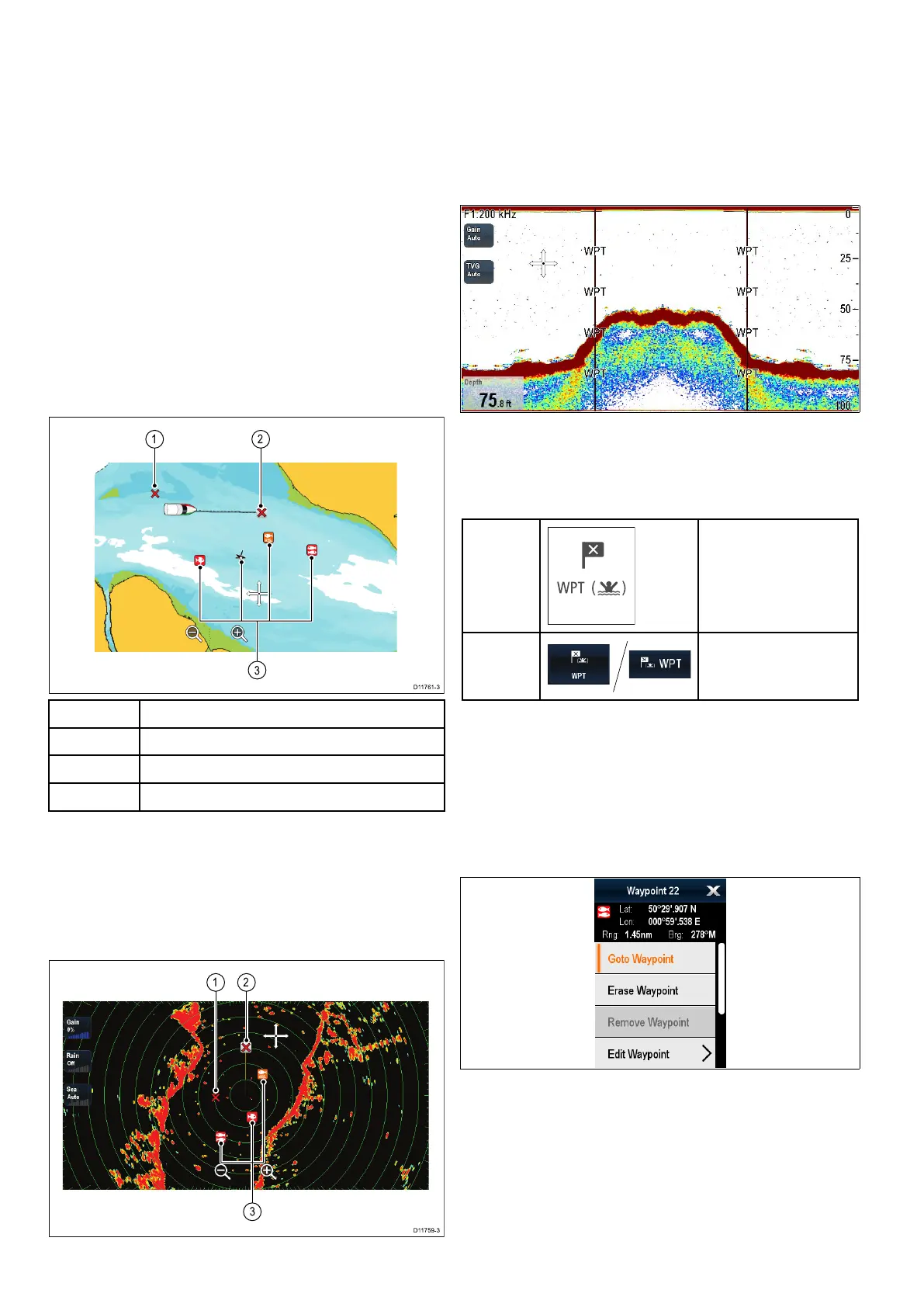
Waypointsintheshnderapplication
Waypointsintheshnderapplicationare
representedbyaverticallinelabelledWPT .
Waypoint(MOB)button/icon
Dependingonthemultifunctiondisplayvariant
therewillbeeitheraWaypoint(MOB)buttonoran
onscreenicon.
WPT
button
•cSeries
•eSeries
•eSSeries
•RMK-9keypad
WPT
icons
•aSeries
•gSSeries
Throughoutthismanualtheterm:SelectWPT,refers
topressingthephysicalWPTbuttonorpressingthe
on-screenWPTicon.
Waypointcontextmenu
Placingthecursoroverawaypointinthechartor
radarapplicationsdisplaysacontextmenushowing
thewaypoint'spositionaldataandmenuitems.
Thecontextmenuprovidesthefollowingpositional
dataforthewaypointinrelationtoyourvessel:
•Latitude
•Longitude
•Range
•Bearing
Forinactivewaypointsthefollowingmenuitemsare
available:
142
LightHousemultifunctiondisplayoperationinstructions
 Loading...