14.19Depth&Contouroptions
Ifsupportedbyyourcartographytype,thefollowingdepthandcontoursettingsareavailable.
Note:ThetablebelowidentiestheDepth&Contouroptionssupportedbyeachcartographyvendor,
howevertheoptionmaynotbesupportedbyalllevelsofcartographysuppliedbythatvendor.Please
checkwithyourcartographyvendorforsupportedfeatures.
MenuitemDescriptionLightHouseNavionics
®
Jeppesen
®
HighResBathyDetermineswhetherJeppesen’sHigh
ResolutionBathymetryValueAddedData
(VAD)isdisplayed.
Note:
•VADisavailableatanadditionalcost
fromJeppesen.
•VADmaynotbeavailableinallareas.
ShowSoundings
Determinesthedepthatwhichdepth
soundingsaredisplayed.
ShowContours
Determineswhethercontoursaredisplayed.
ShallowWaterDeterminesthedepthatwhichtheShallow
contourisdisplayed.
TheShallowcontourcannotbesettoavalue
greaterthantheSafetyorDeepcontours.
SafeWaterFromDeterminesthedepthatwhichtheSafety
contourisdisplayed.
TheSafetycontourcannotbesettoavalue
lessthantheShallowcontourorhigherthan
theDeepcontour.
DeepWaterFromDeterminesthedepthatwhichtheDeep
contourisdisplayed.
TheDeepcontourcannotbesettoavalue
lessthantheShalloworSafetycontours.
DeepWaterColor
DetermineswhetherDeepWateriscolored
BlueorWhite.
SonarLogsAllowsloggingofdepthandpositiondata
toyourNavionicschartcard.Thisdatawill
besenttoNavionicstoimprovethecontour
detailofSonarChartsonyourmultifunction
display.RefertotheNavionicswebsite
www.navionics.comforinstructionsonhowto
uploadyoursonarlogs.
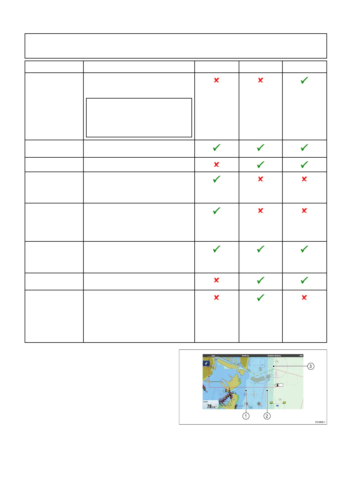
Depthsoundingsandcontours
Ifsupportedbyyourcartographytype,depth
soundingsandcontourscanbeusedintheChart
applicationtoprovideawarenessofwaterdepth.
Whenusingvectorbasedcartographyyoucanadjust
thedepthatwhichthecontoursandsoundings
appearon-screen.
1.ShallowWater
2.SafeWaterFrom
3.DeepWaterFrom
TheDepth&Contoursmenucanbeaccessedfrom:
Menu>Presentation>Depth&Contours.
Chartapplication
195
 Loading...