EasyManuals Logo
Home>Clarion>Car Video System>NX505E

Clarion NX505E User Manual

Clarion NX505E
164 pages
To Next Page IconTo Next Page
To Previous Page IconTo Previous Page
Page #81 background imageLoading...
Page #81 background image
Enter motorway.
Exit motorway.
Board ferry.
Leave ferry.
Approaching a waypoint.
Approaching the destination.
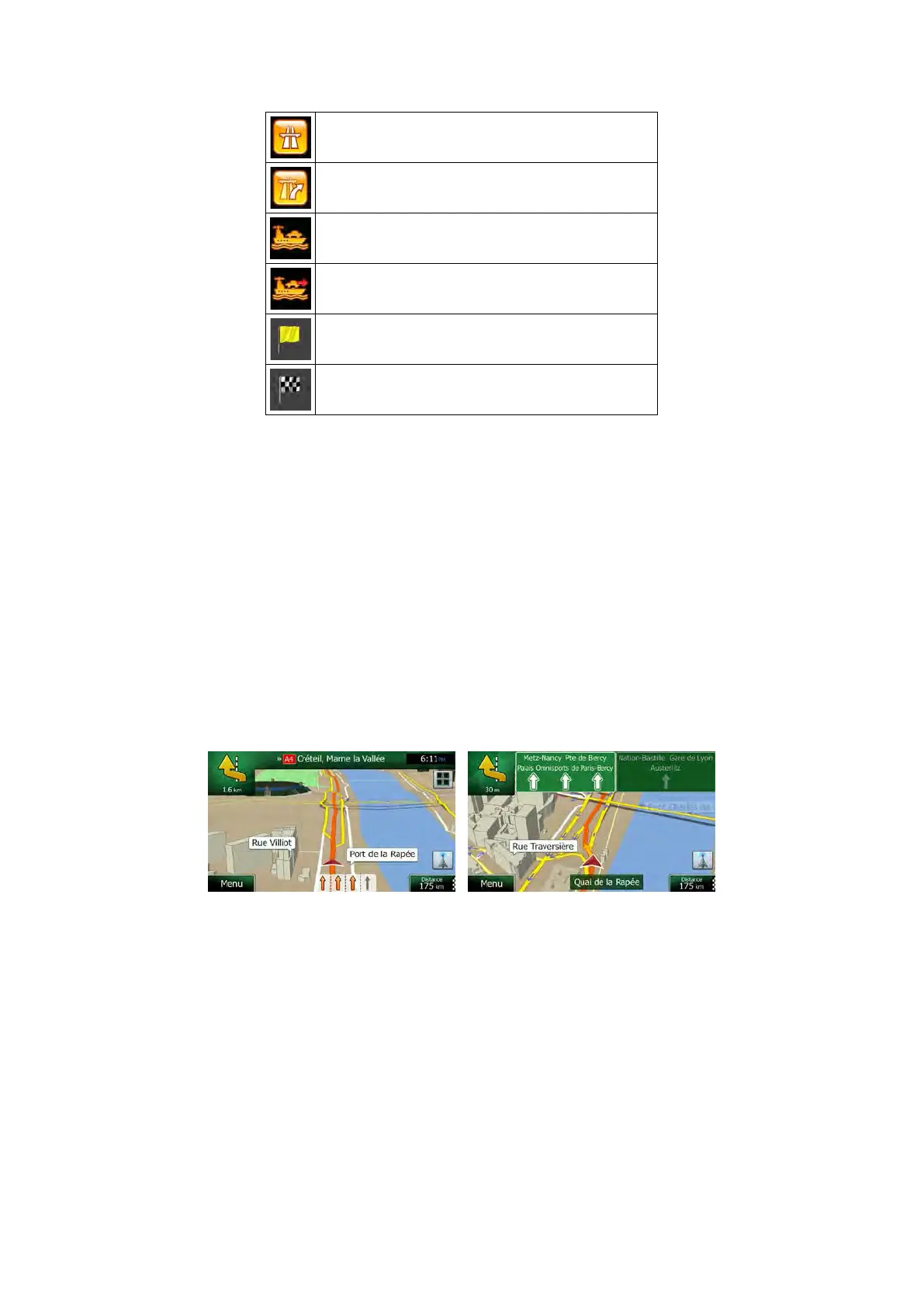
2.3.3.3 Lane information and Signposts
When navigating on multilane roads, it is important to take the appropriate lane in order to
follow the recommended route. If lane information is available in the map data, Clarion Mobile
Map displays the lanes and their directions using small arrows at the bottom of the map.
Highlighted arrows represent the lanes and direction you need to take.
Where additional information is available, signposts substitute arrows. Signposts are
displayed at the top of the map. The colour and style of the signposts are similar to the real
ones you can see above road or by the roadside. They show the available destinations and
the number of the road the lane leads to.
All signposts look similar when cruising (when there is no recommended route). When
navigating a route, only the signpost that points to the lane(s) to be taken is displayed in vivid
colours; all others are darker.
If you want to hide the currently displayed signposts, tap any of them and the normal Map
screen returns until new signpost information is received.
16 NX505E English

Table of Contents

Questions and Answers:

Question and Answer IconNeed help?

Do you have a question about the Clarion NX505E and is the answer not in the manual?

Clarion NX505E Specifications

General IconGeneral
Widescreen-
Display diagonal6.2 \
Display resolution800 x 480 pixels
AM band range531 - 1602 kHz
FM band range87.5 - 108 MHz
Supported radio bandsAM, DAB, FM
Built-in cameraNo
Lifetime map updatesRoads change, but with Lifetime Map Updates your map will always be up to date. Start fresh every few months by downloading a new edition of the industry's most accurate map. New editions are issued four times per year.
Storage media typeMemory card
Compatible memory cardsMicroSD (TransFlash)
Product colorBlack
Weight and Dimensions IconWeight and Dimensions
Depth157 mm
Width178 mm
Height100 mm
Weight- g

Related product manuals