Groundtripresetsmenu
Thismenuenablesyoutoresetsthechosengroundtripdistancecountertozero.
MenuitemDescription
GroundTrip1Reset
Resetsthegroundtrip1distancecountertozero.
GroundTrip2Reset
Resetsthegroundtrip2distancecountertozero.
GroundTrip3Reset
Resetsthegroundtrip3distancecountertozero.
GroundTrip4Reset
Resetsthegroundtrip4distancecountertozero.
Systemsettingsmenu
MenuitemDescriptionOptions
AutopilotControl
Enablesanddisables
autopilotcontrolsfrom
yourmultifunction
display.
•On
•Off
DSCAlerts
Enablesanddisables
DSCradioalertsonyour
multifunctiondisplay.
•On
•Off
GPSSet-upProvidesGPSsetting
options.
•ViewSatelliteStatus
•DifferentialGPS
•COG/SOGFilter
•RestartGPS
InternalGPSSwitchesthe
multifunctiondisplays
internalGPSOnorOff.
Note:TheInternal
GPSoptionisnot
availableonthee165
multifunctiondisplay.
•On
•Off
DataSourcesEnablesselectionof
preferredsourcesof
dataforconnected
equipment.
Note:TheData
Sourcesmenuisonly
availableondisplays
setasDataMaster.
•GPS
•GPSDatum
•TimeandDate
•Heading
•Depth
•Speed
•Wind
ExternalDevices
Enablesset-upof
compatibleexternally
connecteddevices.
RefertotheExternal
devicesmenusectionof
themanual.
Wireless
Connections
Providesaccesstothe
Wi-Fiandbluetooth
connectionoptions.
RefertotheWireless
connectionsmenu
sectionofthemanual.
NMEASet-upEnablesyoutocongure
settingsforNMEA
devices.
RefertotheNMEA
set-upmenusectionof
themanual.
System
Preferences
Enablesyoutocongure
systemsettings
RefertotheSystem
preferencesmenu
sectionofthemanual.
SimulatorSwitchessimulator
modeOnorOff.
•Off
•On
•On(Demomovie)
GPSsetup
TheGPSsetupoptionsenableyoutocongureaconnected
GPSreceiver.
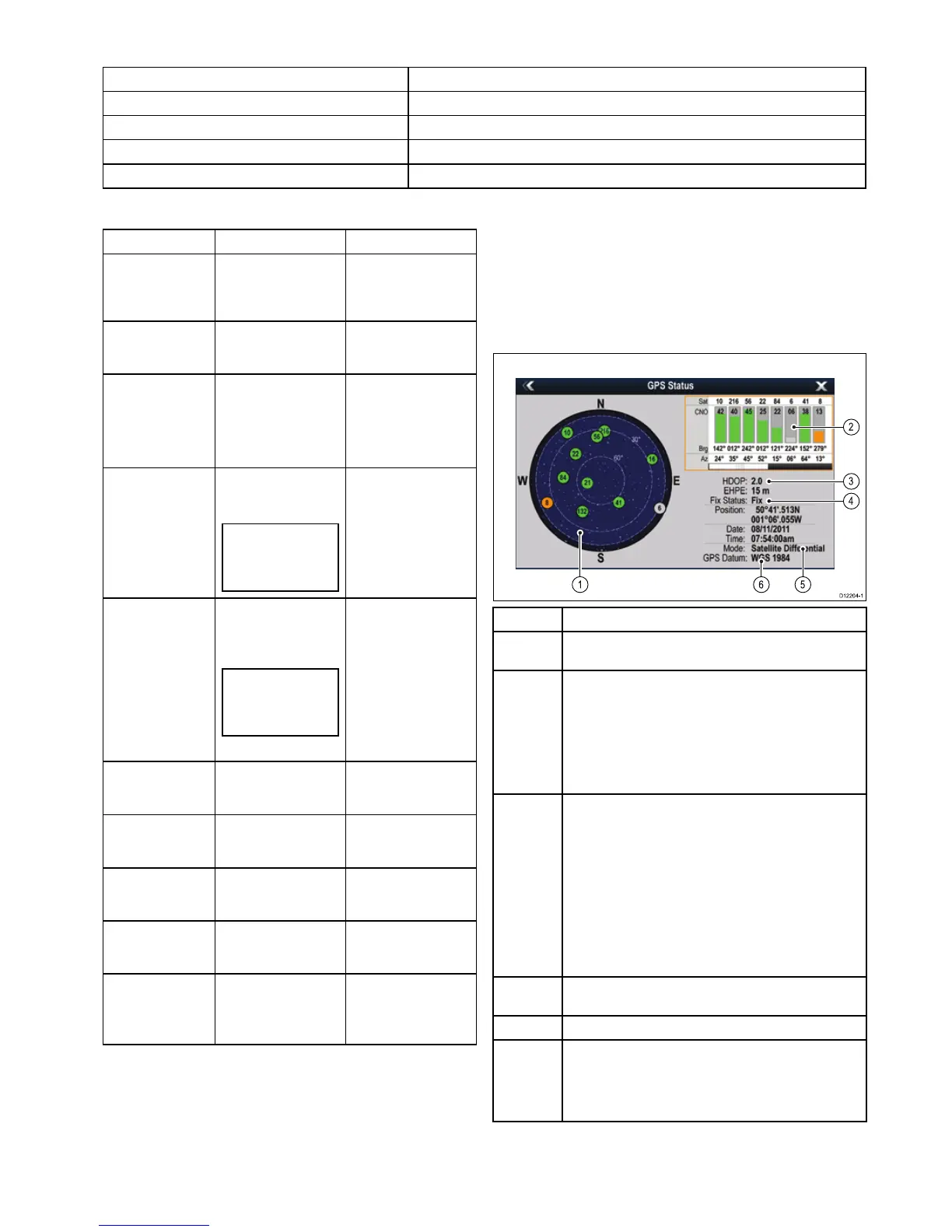
TheGlobalPositioningSystem(GPS)isusedtopositionyour
vesselonthechart.YoucansetupyourGPSreceiverand
checkitsstatusfromtheGPSStatusoptionintheSystem
Settingsmenu.Foreachtrackedsatellite,thescreenprovides
thefollowinginformation:
•Satellitenumber.
•Signalstrengthbar.
•Status.
•Azimuthangle.
•Elevationangle.
•Asky-viewtoshowthepositionoftrackedsatellites.
ItemDescription
1
Skyview—avisualrepresentationofthepositionoftracked
satellites.
2
Satellitestatus—displaysthesignalstrengthandstatusof
eachsatelliteidentiedintheskyviewdiagramontheleftof
thescreen.Thecoloredbarshavethefollowingmeanings:
•Grey=searchingforsatellite.
•Green=satelliteinuse.
•Orange=trackingsatellite.
3
HorizontalDilutionofPosition(HDOP)—ameasureof
GPSaccuracy,calculatedfromanumberoffactorsincluding
satellitegeometry,systemerrorsinthedatatransmissionand
systemerrorsintheGPSreceiver.Ahigherguresignies
agreaterpositionalerror.AtypicalGPSreceiverhasan
accuracyofbetween5and15m.Asanexample,assuming
aGPSreceivererrorof5m,anHDOPof2wouldrepresent
anerrorofapproximately15m.Pleaserememberthateven
averylowHDOPgureisNOguaranteethatyourGPS
receiverisprovidinganaccurateposition.Ifindoubt,check
thedisplayedvesselpositioninthechartapplicationagainst
youractualproximitytoaknownchartedobject.
4
Fixstatus—indicatestheactualmodetheGPSreceiveris
reporting(NoFix,Fix,DFixorSDFix).
5
Mode—themodecurrentlyselectedbytheGPSreceiver.
6
Datum—TheGPSreceiver'sdatumsettingaffectsthe
accuracyofthevesselpositioninformationdisplayedin
thechartapplication.InorderforyourGPSreceiverand
multifunctiondisplaytocorrelateaccuratelywithyourpaper
charts,theymustbeusingthesamedatum.
TheaccuracyoftheGPSreceiverdependsontheparameters
detailedabove,especiallytheazimuthandelevationangles
whichareusedintriangulationtocalculateyourposition.
Customizingyourdisplay
281

 Loading...


