6.9Systemchecks
GPSCheck
GPSselection
Youcanuseaninternal(ifavailable)orexternalGPSreceiver.
•Y ourmultifunctiondisplaymayfeatureaninternalGPS
receiver.
•Y oucanalsoconnectanexternalGPSreceiverusing
SeaTalk
ng
orNMEA0183.
•WhereappropriateusetheSystemSettingsmenutoenable
ordisabletheinternalGPSreceiver.
EnablingordisablingtheinternalGPS
IfyourmultifunctiondisplayfeaturesaninternalGPSthenthis
canbeenabledanddisabledbyfollowingthestepsbelow.
Withthehomescreendisplayed:
1.SelectSet-Up.
2.SelectSystemSettings.
3.T oenabletheinternalGPS,selectInternalGPSsothatOn
ishighlighted.
4.T odisabletheinternalGPS,selectInternalGPSsothatOff
ishighlighted.
CheckingGPSoperation
YoucancheckthattheGPSisfunctioningcorrectlyusingthe
chartapplication.
1.SelecttheChartpage.
2.Checkthescreen.
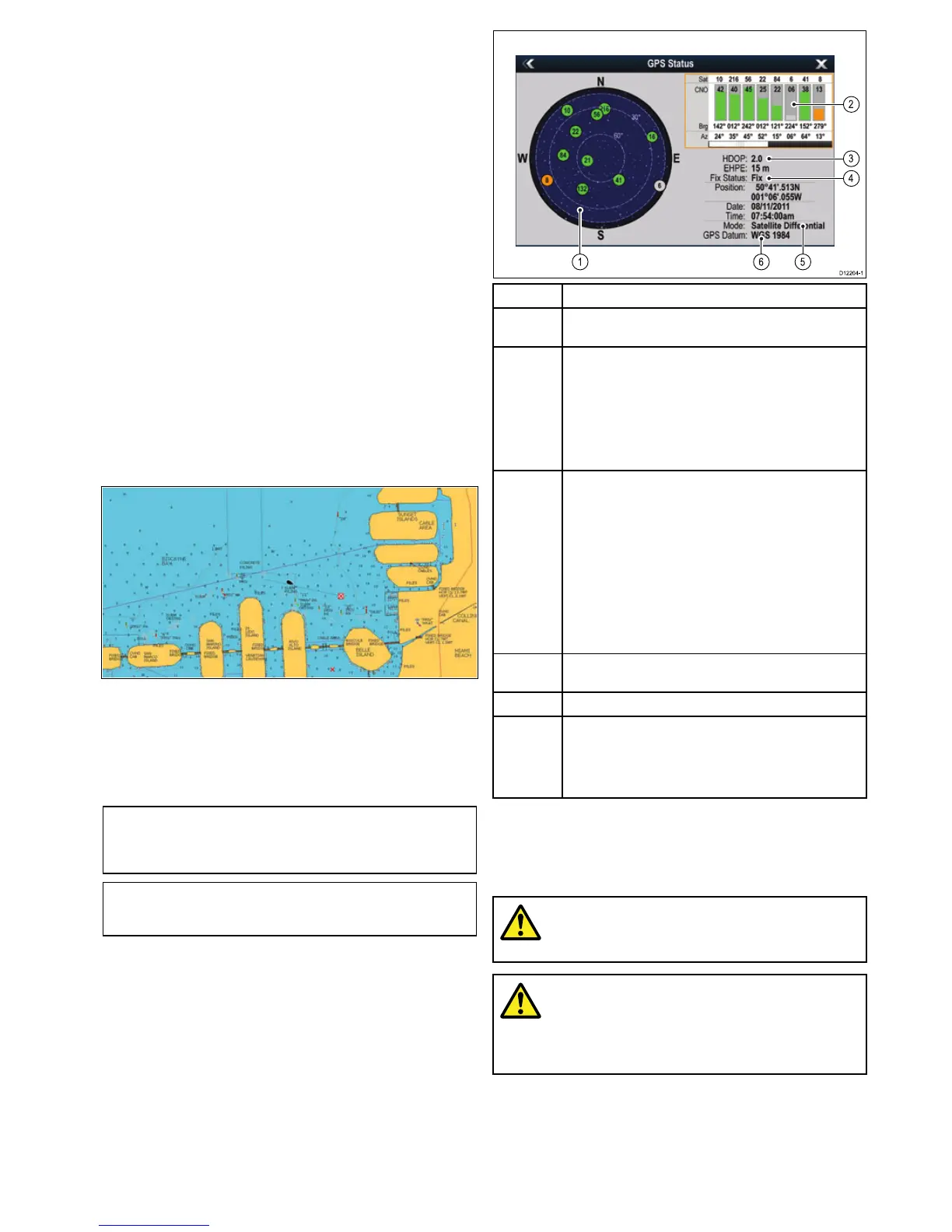
Withthechartdisplayed,youshouldsee:
Yourboatposition(indicatesaGPSx).Yourcurrent
positionisrepresentedbyaboatsymbolorsolidcircle.Your
positionisalsodisplayedinthedatabarunderVESPOS.
Asolidcircleonthechartindicatesthatneitherheadingnor
CourseOverGround(COG)dataisavailable.
Note:Raymarinerecommendsthatyoucheckthedisplayed
vesselpositioninthechartapplicationagainstyouractual
proximitytoaknownchartedobject.GPSreceiverstypically
haveanaccuracyofbetween5and15m.
Note:AGPSStatusscreenisavailablewithintheSetup
menuofRaymarinemultifunctiondisplays.Thisprovides
satellitesignalstrengthandotherrelevantinformation.
GPSsetup
TheGPSsetupoptionsenableyoutocongureaconnected
GPSreceiver.
TheGlobalPositioningSystem(GPS)isusedtopositionyour
vesselonthechart.YoucansetupyourGPSreceiverand
checkitsstatusfromtheGPSStatusoptionintheSystem
Settingsmenu.Foreachtrackedsatellite,thescreenprovides
thefollowinginformation:
•Satellitenumber.
•Signalstrengthbar.
•Status.
•Azimuthangle.
•Elevationangle.
•Asky-viewtoshowthepositionoftrackedsatellites.
ItemDescription
1
Skyview—avisualrepresentationofthepositionoftracked
satellites.
2
Satellitestatus—displaysthesignalstrengthandstatusof
eachsatelliteidentiedintheskyviewdiagramontheleftof
thescreen.Thecoloredbarshavethefollowingmeanings:
•Grey=searchingforsatellite.
•Green=satelliteinuse.
•Orange=trackingsatellite.
3
HorizontalDilutionofPosition(HDOP)—ameasureof
GPSaccuracy,calculatedfromanumberoffactorsincluding
satellitegeometry,systemerrorsinthedatatransmissionand
systemerrorsintheGPSreceiver.Ahigherguresignies
agreaterpositionalerror.AtypicalGPSreceiverhasan
accuracyofbetween5and15m.Asanexample,assuming
aGPSreceivererrorof5m,anHDOPof2wouldrepresent
anerrorofapproximately15m.Pleaserememberthateven
averylowHDOPgureisNOguaranteethatyourGPS
receiverisprovidinganaccurateposition.Ifindoubt,check
thedisplayedvesselpositioninthechartapplicationagainst
youractualproximitytoaknownchartedobject.
4
Fixstatus—indicatestheactualmodetheGPSreceiveris
reporting(NoFix,Fix,DFixorSDFix).
5
Mode—themodecurrentlyselectedbytheGPSreceiver.
6
Datum—TheGPSreceiver'sdatumsettingaffectsthe
accuracyofthevesselpositioninformationdisplayedin
thechartapplication.InorderforyourGPSreceiverand
multifunctiondisplaytocorrelateaccuratelywithyourpaper
charts,theymustbeusingthesamedatum.
TheaccuracyoftheGPSreceiverdependsontheparameters
detailedabove,especiallytheazimuthandelevationangles
whichareusedintriangulationtocalculateyourposition.
Radarcheck
Warning:Radarscannersafety
Beforerotatingtheradarscanner,ensureall
personnelareclear.
Warning:Radartransmission
safety
Theradarscannertransmitselectromagnetic
energy.Ensureallpersonnelareclearofthe
scannerwhentheradaristransmitting.
Checkingtheradar
FromtheRadarapplication:
1.SelectMenu.
2.SelectPowersothatOnishighlighted.
TheRadarscannerwillnowinitializeinstandbymode.This
processwilltakeapproximately70seconds.
Gettingstarted
77

 Loading...


