190-00870-02 Rev. A
Garmin G950 Pilot’s Guide for the Pilatus PC-6
307
HAZARD AVOIDANCE
SYSTEM
OVERVIEW
FLIGHT
INSTRUMENTS
EIS
AUDIO PANEL
& CNS
FLIGHT
MANAGEMENT
HAZARD
AVOIDANCE
AFCS
ADDITIONAL
FEATURES
APPENDICES INDEX
As previously discussed, the type and orientation of the target in relation to the aircraft affects the intensity
displayed.
When the weather radar system is in either the Weather or Ground Map mode, the system automatically
switches to Standby mode upon landing.
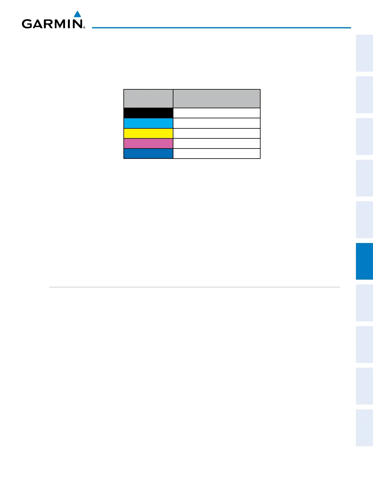
Ground Map
Mode Color
Intensity
Black
0 dB
Cyan
> 0 dB to < 9 dB
Yellow
9 dB to < 18 dB
Magenta
18 dB to < 27 dB
Blue
27 dB and greater
Table 6-2 Ground Target Return Intensity Levels
Operation in Ground Map Mode
1) Press the
MODE Softkey.
2) Press the GROUND Softkey to place the radar in Ground Map mode.
3) Press the BACK Softkey.
4) Press the FMS Knob to activate the cursor.
5) Turn the large
FMS Knob to place the cursor in the TILT field.
6) Adjust the antenna tilt angle by turning the small
FMS Knob to display ground returns at the desired distance.
7) Press the FMS Knob to remove the cursor.
WEATHER RADAR OVERLAY ON THE NAVIGATION MAP PAGE
The Map - Weather Radar Page is the principal map page for viewing airborne weather radar information.
Weather radar information may also be shown as an overlay on the Navigation Map Page on the MFD as an
additional reference.
When the airborne weather radar overlay is enabled, a weather radar information box appears in the upper-
right corner of the Navigation Map Page. It indicates the selected weather mode, radar bearing, and antenna
tilt angle. The overlay is capable of showing radar information while the radar is in horizontal scan mode.
If the radar is operating in vertical scan mode while the overlay is enabled, the system indicates ‘N/A’ in the
information box to indicate the airborne weather radar overlay is not available until the horizontal scan mode
is selected on the Weather Radar Page.
 Loading...