7.1GPSCheck
CheckingGPSoperation
YoucancheckthattheGPSisfunctioningcorrectly
usingthechartapplication.
1.SelecttheChartpage.
2.Checkthescreen.
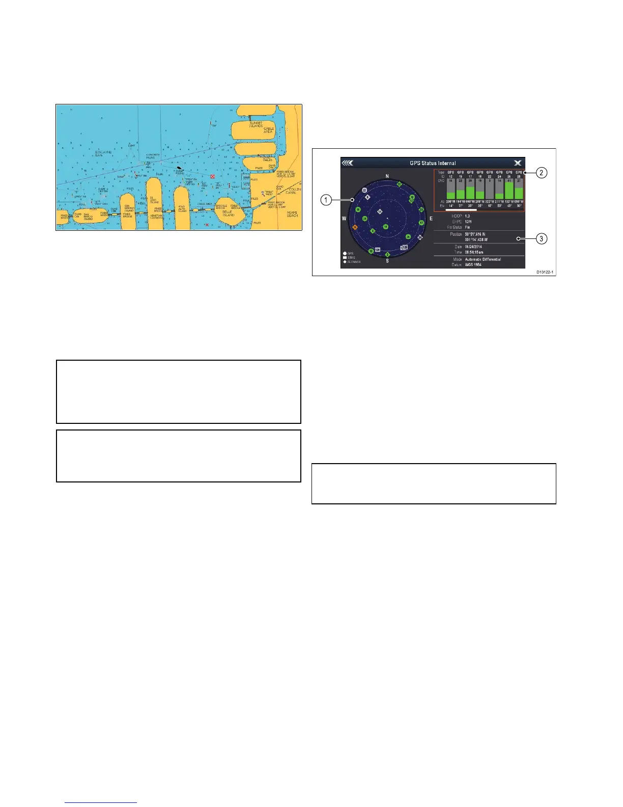
Withthechartdisplayed,youshouldsee:
Yourboatposition(indicatesaGPSx).Your
currentpositionisrepresentedbyaboatsymbol
orsolidcircle.Yourpositionisalsodisplayedin
thedatabarunderVESPOS.
Asolidcircleonthechartindicatesthatneither
headingnorCourseOverGround(COG)data
isavailable.
Note:Raymarinerecommendsthatyoucheckthe
displayedvesselpositioninthechartapplication
againstyouractualproximitytoaknowncharted
object.GPSreceiverstypicallyhaveanaccuracy
ofbetween5and15m.
Note:AGPSStatusscreenisavailablewithinthe
SetupmenuofRaymarinemultifunctiondisplays.
Thisprovidessatellitesignalstrengthandother
relevantinformation.
7.2GPSStatus
TheGPSstatuspageenablesyoutoviewthestatus
oftheavailablesatellitesthatarecompatiblewith
yourreceiver.
Thesatelliteconstellationsareusedtopositionyour
vesselintheChartandWeatherapplications.You
cansetupyourreceiverandcheckitsstatusfrom
theGPSSet-upmenu:Homescreen>Set-up>
SystemSettings>GPSSet-up.Foreachsatellite,
thescreenprovidesthefollowinginformation:
1.Skyview
2.Satellitestatus
3.Positionandxinformation
Skyview
Skyviewisavisualrepresentationthatshows
thepositionofnavigationsatellitesandtheirtype.
Satellitetypesare:
•Circle—Acircleidentiesasatellitefromthe
GPSconstellation.
•*Diamond—Adiamondidentiesasatellitefrom
theGLONASSconstellation.
•Square—Asquareidentiesan(SBAS)
differentialsatellite.
Note:GLONASSsatellitesareonlyavailable
whenconnectedtoacompatiblereceiversuchas
thebuilt-inreceiverofana9xora12xMFD.
Satellitestatusarea
TheSatellitestatusareadisplaysthefollowing
informationabouteachsatellite:
•Type—Identieswhichconstellationthesatellite
belongsto.
•ID—Displaysthesatellitesidenticationnumber.
•CNO(Carrier-to-noiseratio)—Displaysthesignal
strengthofeachsatelliteshownintheSkyview:
–Grey=searchingforsatellite
–Green=satelliteinuse
–Orange=trackingsatellite
•AzimuthandElevation—Providestheangleof
elevationandazimuthbetweenthelocationofthe
receiverandthesatellite.
Positionandxinformation
Thefollowingpositionalandxinformationis
provided:
•HorizontalDilutionofPrecision(HDOP)
—HDOPisameasureofsatellitenavigation
accuracy,calculatedfromanumberoffactors
104
gSSeries
 Loading...