190-00962-04 Rev. A
Garmin G1000 Pilot’s Guide for the Diamond DA42NG
411
HAZARD AVOIDANCE
SYSTEM
OVERVIEW
FLIGHT
INSTRUMENTS
EIS
AUDIO PANEL
& CNS
FLIGHT
MANAGEMENT
HAZARD
AVOIDANCE
AFCS
ADDITIONAL
FEATURES
APPENDICES INDEX
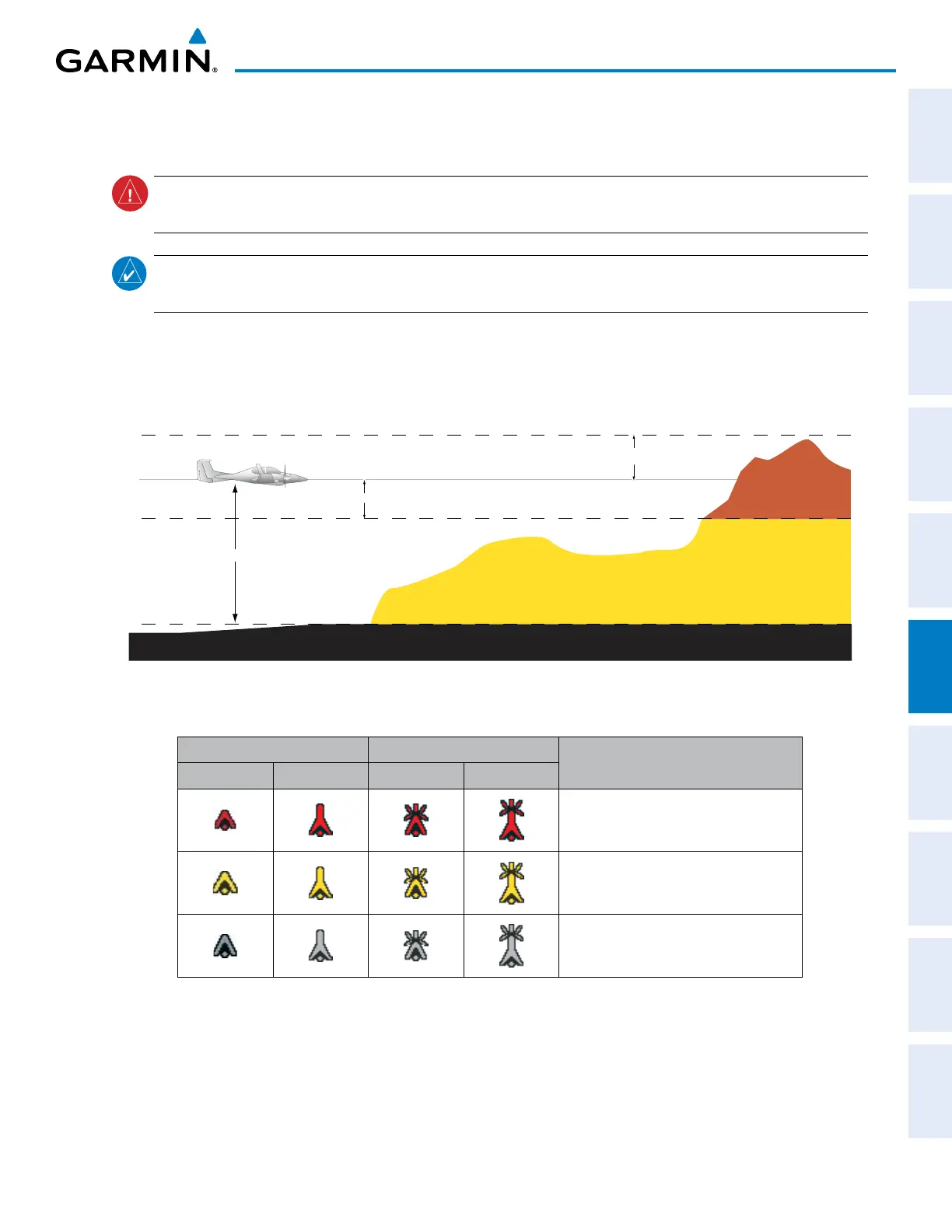
6.7 PROFILE VIEW TERRAIN
WARNING: Do not use Profile View Terrain data for primary terrain avoidance. Profile View Terrain is intended
only to enhance situational awareness.
NOTE: Terrain data is not displayed when the aircraft is outside of the installed terrain database coverage
area.
The G1000 offers a Profile View of terrain and obstacles relative to the aircraft’s current flight path and altitude
on the Navigation Map Page of the MFD. Profile View does not provide terrain or obstacle caution or warning
annunciations or voice alerts, nor does it display potential impact points inside the Profile View. The colors and
symbols in Figure 6-162 and Table 6-22 are used to represent terrain and obstacles.
1000 ft
Aircraft Altitude
100 ft Threshold
Terrain Above Aircraft Altitude
Red terrain is above
or within 100 ft below
the aircraft altitude
Yellow terrain is between 100 ft and 1000 ft below the aircraft altitude
Black terrain is more than 1000 ft below the aircraft altitude
Figure 6-162 Terrain Altitude/Color Correlation for Profile View Terrain
Unlighted Obstacle Lighted Obstacle
Obstacle Location
< 1000’ AGL > 1000’ AGL < 1000’ AGL > 1000’ AGL
Red obstacle is above or within 100 ft
below the aircraft altitude
Yellow obstacle is between 100 ft and
1000 ft below the aircraft altitude
Gray obstacle is more than 1000 ft
below aircraft altitude
Table 6-22 Profile View Terrain/Obstacle Colors and Symbology
Accessing Profile View:
1) Select the Navigation Map Page.
2) Press the MAP Softkey.
3) Press the PROFILE Softkey to enable or disable Profile View.

 Loading...


