190-00962-04 Rev. A
Garmin G1000 Pilot’s Guide for the Diamond DA42NG
433
HAZARD AVOIDANCE
SYSTEM
OVERVIEW
FLIGHT
INSTRUMENTS
EIS
AUDIO PANEL
& CNS
FLIGHT
MANAGEMENT
HAZARD
AVOIDANCE
AFCS
ADDITIONAL
FEATURES
APPENDICES INDEX
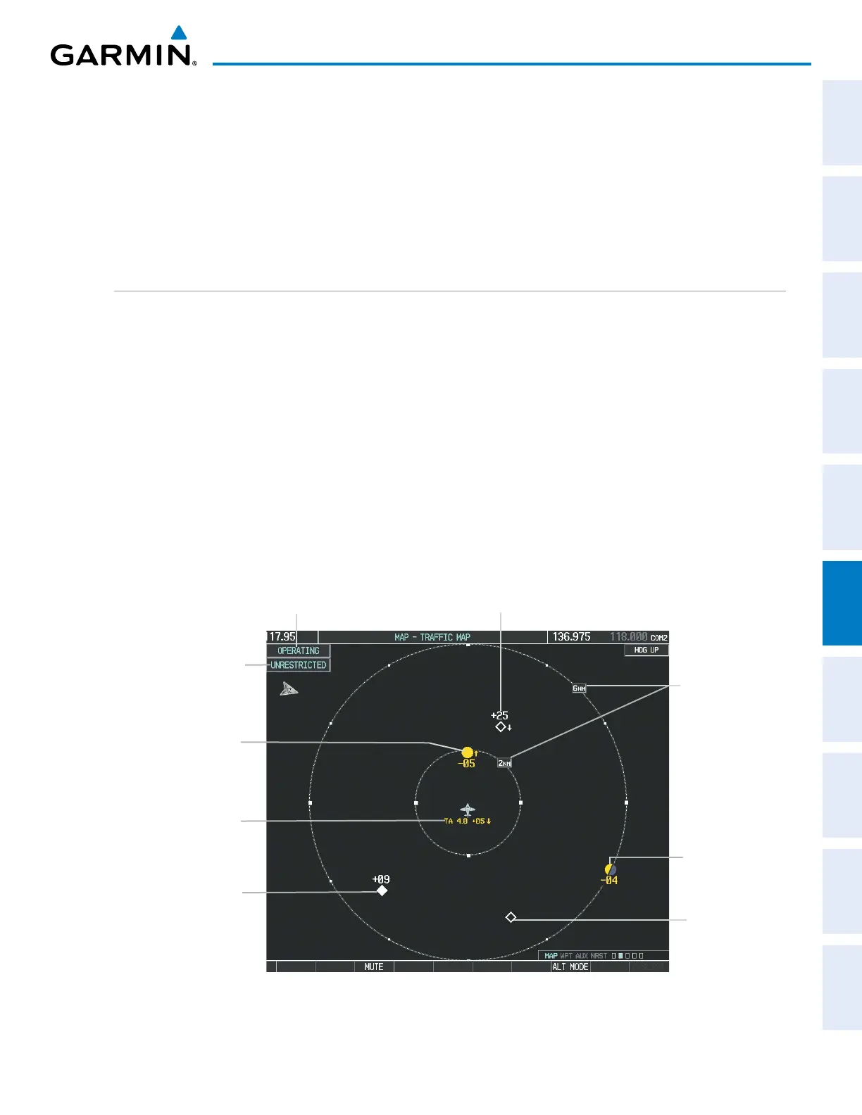
A Non-threat Advisory, shown as an open white diamond, indicates that an intruding aircraft is at greater than
±1200 feet relative altitude or the distance is beyond 5 nm.
A Proximity Advisory indicates that the intruding aircraft is within ±1200 feet and is within 5 nm range, but
is still not considered a threat.
A Traffic Advisory (TA) alerts the crew to a potentially hazardous intruding aircraft. Closing rate, distance,
and vertical separation meet TA criteria. A Traffic Advisory that is beyond the selected display range is indicated
by a half TA symbol at the edge of the screen at the relative bearing of the intruder.
DISPLAYING TRAFFIC DATA
The Map - Traffic Map Page is the principal page for viewing traffic information. Traffic information can
displayed on the following maps as an additional reference:
• PFD Inset Map
• Navigation Map Page
• Trip Planning Page
• Nearest Pages
• Active Flight Plan Page
• AUX - Video Page
Displaying traffic on the Traffic Map Page:
1) Turn the large
FMS
Knob to select the Map Page Group.
2) Turn the small
FMS
Knob
to select the Traffic Map Page.
3) Turn the Joystick clockwise to display a larger area or counter-clockwise to display a smaller area.
Figure 6-186 Traffic Map Page
Altitude
Mode
Proximity Traffic,
900’ Above,
Level
“No Bearing”
Traffic (Bearing
Undetermined),
Distance 4.0
nm, 500’ Above,
Descending
Traffic Advisory, 500’
Below, Climbing
Traffic
Advisory Off-
Scale, 400’
Below, Level
Traffic Display
Range Rings
Non-Threat
Traffic,
Altitude Not
Reported
Non-Threat Traffic, 2500’
Above, Descending
Operating
Mode

 Loading...


