10
GPS/GPS-A OPERATION
10-3
■ Checking GPS Position
You can check your current position.
The GPS position screen is cancelled when [PTT] is
pushed. After releasing, the screen automatically appears.
During transmission, the GPS position screen can be se-
lected by pushing [QUICK] .
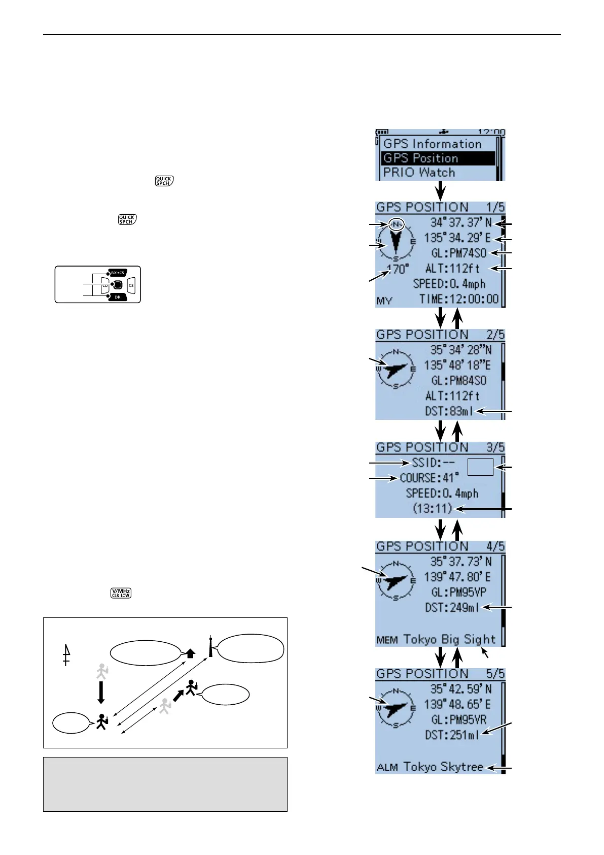
Displaying Position Data D
Push [QUICK] q to open the Quick Menu screen.
Push D-pad( w ) to select “GPS Position,” and then
push D-pad(Ent).
The first MY GPS position screen appears. (1/5)
Push D-pad( e ) to view other position screens.
• MY Position :
Latitude, Longitude, Grid Locator, Altitude,
Speed*, Time and Course* are displayed.
A compass heading is also displayed.
• RX Position 1 : The RX station’s position in Latitude,
Longitude, Grid Locator, Altitude are dis-
played. Also, the Distance and Direction
from you are displayed.
• RX Position 2 : The SSID, Course, Speed and Time stamp
of the RX station is displayed.
Depending on the activity of the RX sta-
tion, some data may not be displayed.
• MEM Position:
The position of the GPS memory location
in Latitude, Longitude and Grid Locator are
displayed. Also, the Distance and Direction
from you to the location is displayed.
• ALM Position: The position of the GPS memory location
for the GPS alarm function in Latitude,
Longitude and Grid Locator are displayed.
Also, the Distance and Direction from you
to the location is displayed.
* Data entered manually in the “Manual Position” Edit
option is not displayed. (p. 16-32)
(MENU > GPS > GPS Set > GPS Select)
Push [CLR] r
to cancel the GPS POSITION
screen and return to the operating screen.
MEM Position
The direction
from you to
the memory
location.
The location is
east-northeast
of you.
* When a name is not assigned to the memory channel,
Day and Time are displayed instead of the name.
NOTE: The latitude, longitude and altitude may differ,
depending on your GPS selection of either the inter-
nal or an external GPS receiver. Also, the time may
not be displayed, depending on the external GPS.
Your
station
GPS memory:
Tokyo Big Sight
GPS alarm:
Tokyo Skytree
Course is 170 degrees Speed is 0.4 mph.
251 ml
249 ml
Course is 41 degrees
Speed is 0.4 mph.
• Example of the GPS data screens to the right
RX station
MY Position
Latitude
Compass
direction Top
is North
Your course
heading is
north-east
Longitude
Grid Locator
Your course
heading is
170 degrees
RX Position 1
RX Position 2
The direction of
the RX station
from you.
The station is
east-northeast
of you.
The distance
from you to
the station
Altitude
The course
heading of the
RX station is
41 degrees
from north.
Shows the SSID
if the RX station
has entered.
The
distance
from you to
the memory
location
*
*
The direction
from you to the
alarm location.
The location is
east-northeast
of you.
ALM Position
The
distance
from you to
the alarm
location
Shows the
time the
RX station
acquires the
position.
Shows the
GPS-A
symbol
 Loading...