EasyManuals Logo

Garmin G3X Touch Pilot's Guide

Garmin G3X Touch
450 pages
To Next Page IconTo Next Page
To Previous Page IconTo Previous Page
Page #240 background imageLoading...
Page #240 background image
Garmin G3X Touch
Pilot’s Guide for Certified Aircraft
190-02472-00 Rev. D
218
Hazard Avoidance
System
Overview
Flight
InstrumentsEIS
CNS
Interface
GPS
Navigation
Flight
Planning
Hazard
Avoidance
Additional
FeaturesAFCSAnnun/AlertsAppendixIndex
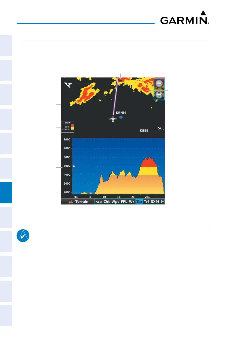
TERRAIN VIEWS
Two views are displayed on the Terrain (Ter) Page: the Map View, and the Profile
View.
Yellow Terrain is
Between the User-
defined Caution
Elevation and
100 ft Below the
Aircraft
Terrain Legend
Red Terrain is above
the aircraft, or
within 100 ft below
the aircraft.
Terrain (Ter) Page
Map View
Profile View
Obstacle
NOTE:
When on the ground, the terrain color scale changes so no yellow
is shown, and the red band starts at 400 feet above the aircraft. This
allows the pilot to quickly identify threatening terrain while on the
ground. After the aircraft is airborne, the terrain display reverts to
normal.

Table of Contents

Other manuals for Garmin G3X Touch

Questions and Answers:

Question and Answer IconNeed help?

Do you have a question about the Garmin G3X Touch and is the answer not in the manual?

Garmin G3X Touch Specifications

General IconGeneral
Power Input10-32 VDC
TouchscreenYes
Built-in GPSYes
AHRSYes
Air Data ComputerYes
Aviation DatabaseYes
Terrain AwarenessYes
Operating Temperature-20°C to +55°C
Display Size10.6 inches
Display TypeLCD
ConnectivityWi-Fi, Bluetooth, USB, RS-232, CAN bus
Engine MonitoringYes
Autopilot CompatibilityYes
Traffic AwarenessYes
Weather DataYes

Related product manuals