190-00962-02 Rev. A
Garmin G1000 Pilot’s Guide for the Diamond DA42NG
395
HAZARD AVOIDANCE
SYSTEM
OVERVIEW
FLIGHT
INSTRUMENTS
EIS
AUDIO PANEL
& CNS
FLIGHT
MANAGEMENT
HAZARD
AVOIDANCE
AFCS
ADDITIONAL
FEATURES
APPENDICES INDEX
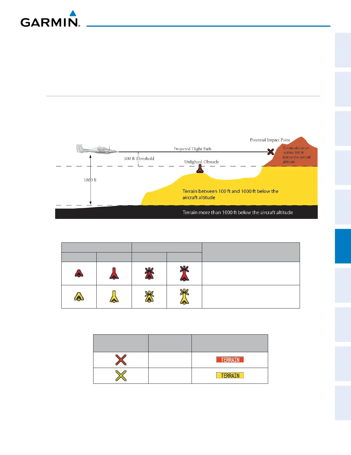
TerrainandobstacledatabasesarereferencedtoMSL.UsingtheGPSpositionandaltitude,theTerrain-SVS
featureportraysa3-Dpictureofthesurroundingterrainandobstaclesrelativetothepositionandaltitudeofthe
aircraft.GPSpositionandGSLaltitudeareusedtocalculateandpredicttheaircraft’sightpathinrelationto
thesurroundingterrainandobstacles.Inthisway,thepilotcanviewpredicteddangerousterrainandobstacle
conditions.
DISPLAYING TERRAIN-SVS DATA
Terrain-SVSusesyellow(caution)andred(warning)todepictterrainandobstacles(withheightsgreaterthan
200feetabovegroundlevel,AGL)alertsrelativetoaircraftaltitude.Colorsareadjustedautomaticallyasthe
aircraftaltitudechanges.Thecolorsandsymbolsinthegureandtablesbelowareusedtorepresentterrain,
obstacles, and potential impact points.
Figure 6-147 Terrain Altitude/Color Correlation for Terrain-SVS
Unlighted Obstacle Lighted Obstacle
Obstacle Location
< 1000’ AGL > 1000’ AGL < 1000’ AGL > 1000’ AGL
Red obstacle is above or within 100 ft
below the aircraft altitude
Yellow obstacle is between 100 ft and
1000 ft below the aircraft altitude
Table 6-22 Terrain-SVS Obstacle Colors and Symbology
Potential Impact
Point Symbol
Alert Type Example Annunciation
Warning
Caution
Table 6-23 Terrain-SVS Potential Impact Point Symbols with Alert Types

 Loading...


