Garmin G1000 Pilot’s Guide for the Diamond DA42NG
190-00-00962-02 Rev. A
414
HAZARD AVOIDANCE
SYSTEM
OVERVIEW
FLIGHT
INSTRUMENTS
EIS
AUDIO PANEL
& CNS
FLIGHT
MANAGEMENT
HAZARD
AVOIDANCE
AFCS
ADDITIONAL
FEATURES
APPENDICESINDEX
DISPLAYING TRAFFIC DATA
TheMap-TrafcMapPageistheprincipalpageforviewingtrafcinformation.Trafcinformationcan
displayedonthefollowingmapsasanadditionalreference:
•PFDInsetMap
•NavigationMapPage
•TripPlanningPage
•NearestPages
•ActiveFlightPlanPage
•AUX-VideoPage
Displaying traffic on the Traffic Map Page:
1) Turn the large
FMS
Knob to select the Map Page Group.
2) Turn the small
FMS
Knob
to select the Traffic Map Page.
3) Turn the RANGE Knob clockwise to display a larger area or counter-clockwise to display a smaller area.
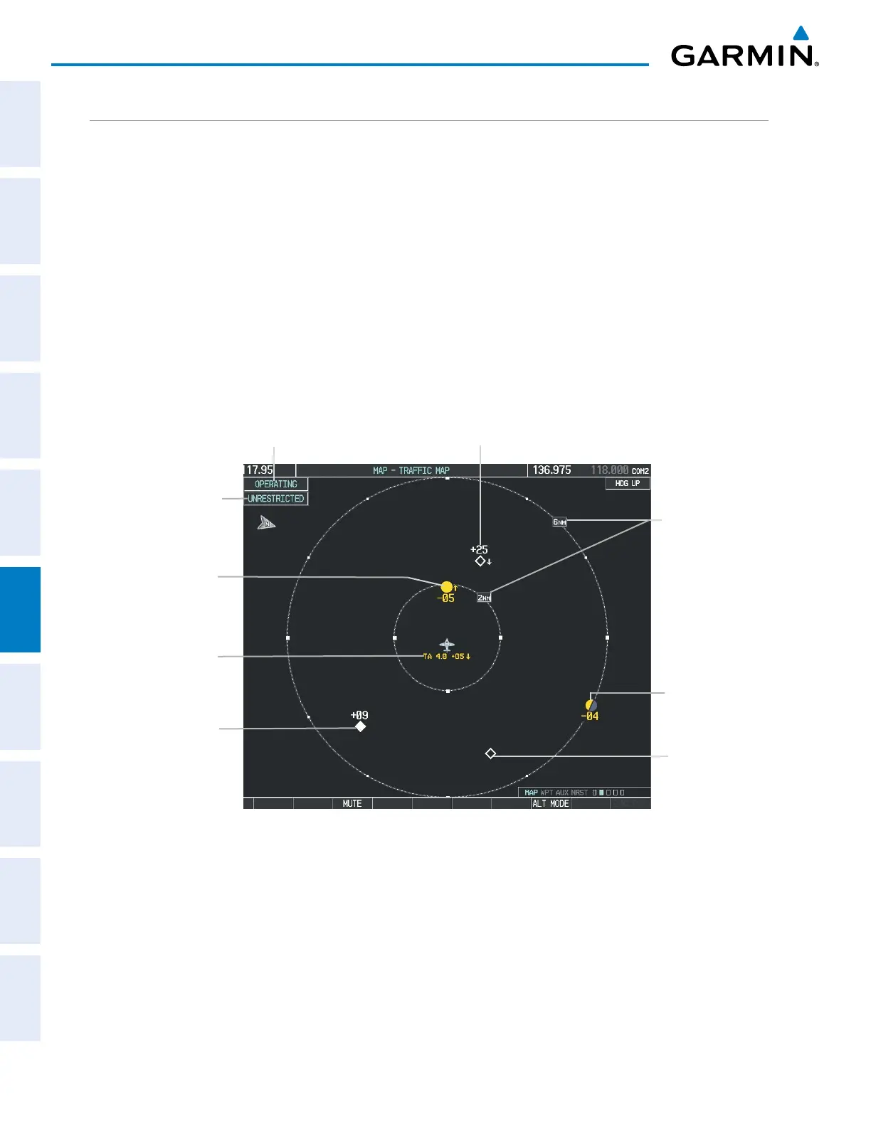
Figure 6-165 Traffic Map Page
Altitude
Mode
Proximity Traffic,
900’ Above,
Level
“No Bearing”
Traffic (Bearing
Undetermined),
Distance 4.0
nm, 500’ Above,
Climbing
Traffic Advisory, 500’
Below, Climbing
Traffic
Advisory Off-
Scale, 400’
Below, Level
Traffic Display
Range Rings
Non-Threat
Traffic,
Altitude Not
Reported
Non-Threat Traffic, 2500’
Above, Descending
Operating
Mode
TheTrafcMapPageshowssurroundingTAStrafcdatainrelationtotheaircraft’scurrentpositionand
altitude,withoutbasemapclutter.Aircraftorientationisalwaysheadingupunlessthereisnovalidheading.
MaprangeisadjustablewiththeRANGE Knobfrom2to24nm,asindicatedbythemaprangerings.
Thetrafcmodeandaltitudedisplaymodeareannunciatedintheupperleftcorner.
Displaying traffic information (maps other than the Traffic Map Page):
1) Select the MAP Softkey.
2) Select the TRAFFIC Softkey to display traffic data.

 Loading...


