8
GPS OPERATION
8-4
CheckingyourGPSposition
You can check your current location.
This section is described using received data.
D DisplayingPositionData
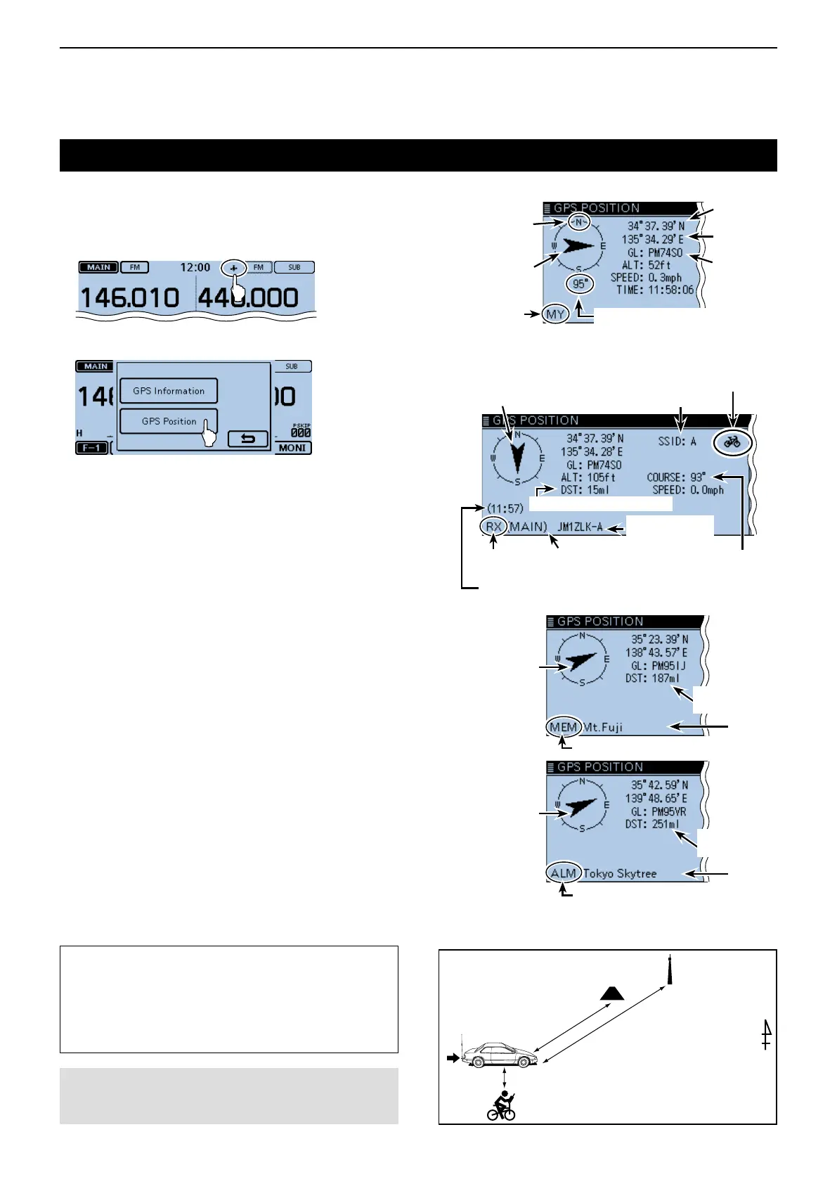
Touch the GPS icon. q
Touch [GPS Position]. w
• Opens the “GPS POSITION” screen.
Touch [ e ∫] or [√] one or more times.
• Selects the page.
• My (MY) screen, the received (RX) screen, the GPS
memory (MEM) channel screen, and the GPS alarm
(ALM) channel screen are selectable.
• MY: Displays your position in latitude and longitude,
grid locator, altitude, speed*, time, compass head-
ing* and direction*.
* Does not appear when “GPS Select” is set to
“Manual.” (p. 12-20)
(GPS > GPS Set > GPS Select)
• RX: Displays the caller station’s position in latitude
and longitude, grid locator, altitude, distance/di-
rection from your position, SSID, course, speed,
TX power level, height, antenna gain, antenna
direction, temperature, rainfall, wind direction,
wind speed, barometric pressure, humidity, Time
stamp, D-PRS symbol, and call sign.
• Depending on the received signal, some data
may not be displayed. (p. 8-6)
• MEM: Displays the GPS memory channel’s position in
latitude and longitude, grid locator, and distance/
direction from your position.
• ALM: Displays the GPS alarm memory channel posi-
tion in latitude and longitude, grid locator, and dis-
tance/direction from your position.
Touch [ r ].
• Closes the “GPS POSITION” screen.
* When a name is not assigned to the memory channel, date
and time are displayed instead of the name.
Foryourreference:
If you transmit when the “GPS POSITION” screen
is displayed, the screen will be cancelled. But while
transmitting, you can display the “GPS POSITION”
screen again by touching the GPS icon to check the
position data while transmitting.
NOTE:
Latitude, longitude, and altitude data may differ, de-
pending on your GPS.
[AbouttheGPSPositionscreen]
<MY>
<RX>
When the caller’s TX format is D-PRS Position (Mobie station)
<MEM>
<ALM>
Latitude
Longitude
Grid locator
Your course
heading is
East.
Shows My
position screen
Compass
direction top
is North.
Your course direction is 95° degrees
Distance from your position
Caller’s call sign
with SSID
Shows RX band in the
Dualwatch mode
D-PRS symbol
Shows the time the caller
acquired the position data
Caller’s SSID
Direction from your position
Caller is south of you.
Shows received
position screen
The course heading
of the caller is 93
degrees.
*
Direction from
your position
The location is
east-northeast
of you.
Distance from
your position
Shows the GPS Memory position screen
*
Direction from
your position
The location is
east-northeast
of you.
Distance from
your position
Shows the GPS alarm position screen
15 ml
Course: degrees
Speed: 0.0 mph
Callerstation (D-PRS: mobie)
GPS memory:
Mt.Fuji
GPS alarm:
Tokyo Skytree
187 ml
251 ml
Thisisan
examplefor
the GPS data
screens
Yourstation
Course: 95 degrees
Speed: 1.4 mph
 Loading...