12
MENU SCREEN
12-32
GPSMessage
GPS > GPS TX Mode > NMEA > GPS Message
Enter a GPS message of up to 20 alphanumeric char-
acters. (p. 8-28)
NOTE:When you do not want to send a message,
be sure to delete the message programmed in the
Quick Menu window.
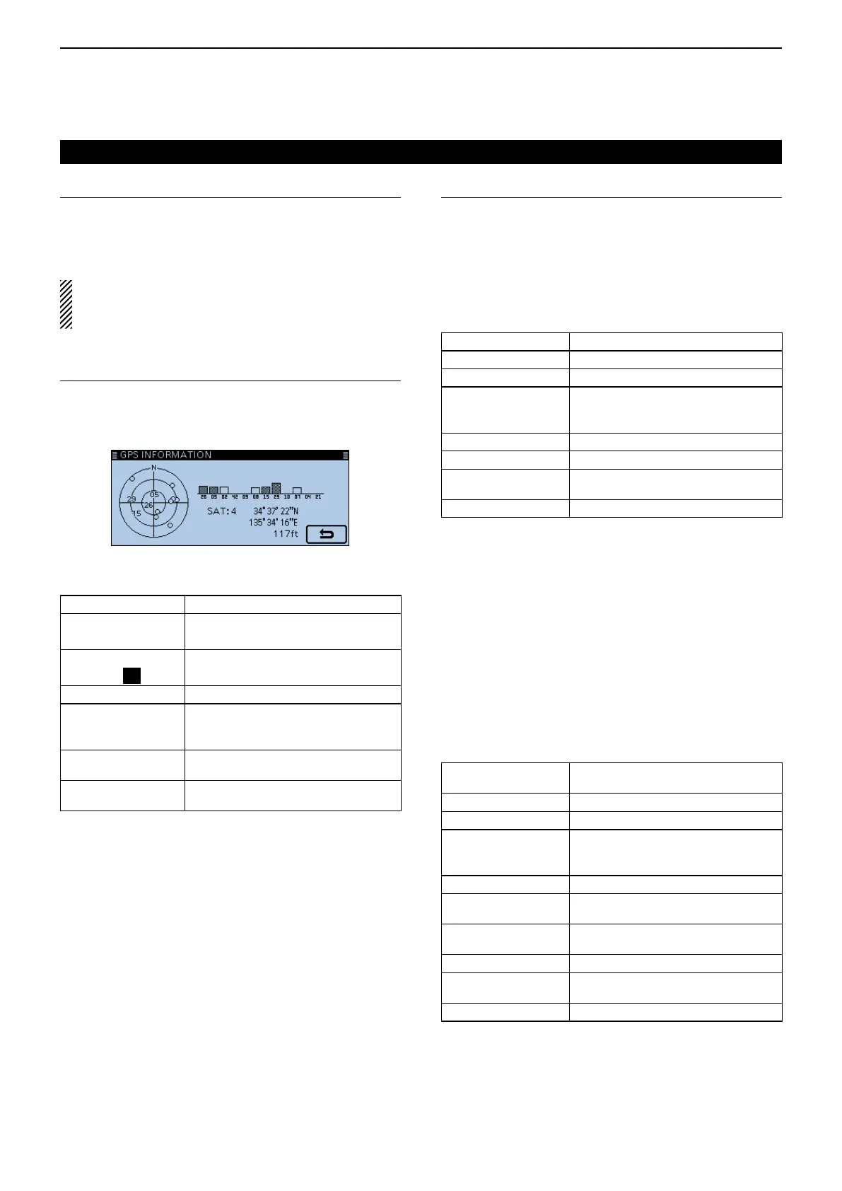
GPSInformation
GPS > GPS Information
Displays the GPS satellite direction, altitude, satellite
number and receiving status. (p. 8-13)
Example: tracking 4 satellites
Non tracking satellites
Regular characters
(Example: 01)
Tracking satellites (weak signal)
Reversed characters
(Example:
01
)
Tracking satellites (strong signal)
SAT Number of tracking satellite
Altitude
------ft (Non-positioning / 2D (Tracking
three satellite) /Positioning results (4
or more satellite tracking)
Latitude
--°--.--'-(Non-positioning)/Positioning
results
Longitude
---°--.--'-(Non-positioning)/Positioning
results
GPSPosition
GPS > GPS Position
Your current position, received position or GPS memo-
ry alarm position information is displayed. (p. 8-4)
Touch [∫] or [√] one or more times to select the screen
to see the “MY,” “RX,” “MEM” and “ALM” screens.
[MY]screen (MY Position)
Compass* Displays your direction
Latitude Displays your latitude
Longitude Displays your longitude
GL
Displays the grid locator based on
the latitude and longitude of your
position.
ALT Displays your own altitude
SPEED Displays your speed over ground
TIME
Displays current time received from
the GPS
COURSE Displays your direction heading
When the “GPS Select” item is set to “Manual,” the screen
shows only latitude, longitude, altitude, GL (Grid locator), and
time (internal clock).
[RX]screen(Received position of the other station)
Depending on the caller’s TX mode or TX format, the
displayed items and these meanings are differ.
The following lists describe the items for each catego-
ry.
Nothing is displayed when no position data is received
on your transceiver.
1.Whenthecaller’sTXmodeisNMEA
Compass*
Displays the caller’s direction from
your position.
Latitude Displays the caller’s latitude
Longitude Displays the caller’s longitude
GL
Displays the grid locator based on the
latitude and longitude of the caller’s
position.
ALT Displays the caller’s altitude
DST
Displays the caller’s distance from
your position
COURSE
Displays the caller’s direction over
ground
SPEED Displays the caller’s speed
GPS Time Stamp
Displays the time that the caller
acquired the position data.
Call sign Displays the caller’s call sign
GPS items (Continued)
*These items can be selected in the Quick Menu screen.
 Loading...